
Wrightsville Beach Surf Outlook: October 3-10, 2025
Issued 9:15 AM October 3. Note: This content will become less and less relevant with time.
-
- E trending SE windswell/swell lingers through the weekend and early next week
- Onshore winds persist with plenty of rideable albeit chunky surf on tap
- Gradually improving conditions with easing surf into midweek
- Watching for renewed windswell later next week
Discussion:
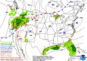
Spectral buoy analysis shows a mix of short period easterly windswell and fading mid to longer period tropical swell across the area. This is producing continued surf in the waist to chest high zone across the area. Strong, fall-like high pressure north of the area will gradually slide offshore through the end of the weekend and early next week. This will allow the E windswell to trend more from the SE, with continued surf in the 2-4’ (thigh-waist-chest high) zone on the face for the next few days. The problem will be onshore winds and bumpy conditions, but there will be times when the onshores aren’t overly strong, especially in the mornings.
Overall Best Weekend Window: Early mornings both Saturday and Sunday. Having surf won’t be the issue this weekend, but the winds/conditions will be problematic. Early high tides will also cut through some of the chop, but be selective with your spot choices considering the high tides early. All of this being said, there probably won’t be a major difference in conditions throughout the weekend, so if you want to get wet, get wet and don’t stress the timing.
Similar surf continues into early next week with marginal 2-4’ surf and onshore winds persisting. Standout spots see occasional chest/shoulder high sets. There is some indication a modest weakness in the pressure pattern will occur around mid week (late Tuesday/Wednesday) as high pressure continues to slide offshore and the next front approaches from the west. While surf heights will drop a smidge as this occurs, wind speeds should come down a bit with a net improvement in conditions through Tuesday and Wednesday.
Next Week Bottom Line/Potential Best Days: Rideable but semi choppy/bumpy surf early week. Slightly smaller but a bit less choppy surf for later Tuesday into Wednesday, which is my pick times to target in the extended forecast.
Looking further out, there is decent agreement in the various computer models (both deterministic and ensembles) that another strong, post frontal high pressure system will build in from the north towards the back half of next week. If this verifies, it would lead to another round of building NE to E windswell towards the back half of next week (10/9-10/10), but again with choppy conditions. Lastly, there are a couple of features in the tropics worth watching. While there is no indication of anything imminent that would significantly impact the surf forecast, things can change quickly this time of year.
 Wavewire
 Pics
Pics CAMS
CAMS News
News Contact