
|
BEST SHAPE
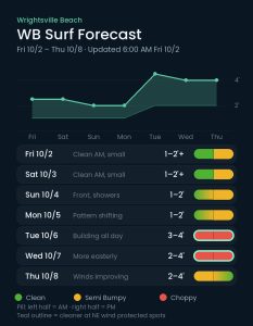
Fri / Sat mornings
|
BIGGEST SURF
Tue / Wed
|
TIMES TO WATCH
Tue / Wed NE surge; Thu as winds gradually improve
|
Conditions Clean · Semi Bumpy · Choppy
Each day’s pill is split — left half is the morning session, right half is the afternoon.
Issued 6:00 AM October 2. Note: Forecast based on early Friday morning (10/2) data. While broad patterns usually hold, forecast shifts occur—verify conditions before heading out.
Friday–Sunday 10/2–10/4 — Minor Mid-Period ESE Swell
Small mid-period ESE swell from recent, distant tropical activity will produce mostly knee, occasionally thigh high surf through the weekend. Offshore high pressure will lead to light morning winds and clean conditions Friday and Saturday mornings, before S to SE winds pick up in the afternoon. Watch for dense fog early Friday, mainly before 9 AM, and it stays warm and humid into Saturday with highs in the mid 80s.
A front moves into the area on Sunday, leading to light onshore winds that trend S in the afternoon, although a continued 1–2′ surf regime. Showers become likely Saturday night and stay with us most of Sunday, with a thunderstorm possible in the afternoon and rain lingering into Monday morning.
Monday–Thursday 10/5–10/8 — Midweek NE Swell Surge
No significant change is expected on Monday, with mostly 1–2′ surf and winds trending N as a series of fronts begins impacting the area. Showers taper off through Monday afternoon.
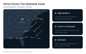
Changes are likely through the middle of next week, however, as stronger high pressure builds in from the Ohio River Valley and transitions over the Mid-Atlantic states. Look for this to produce a surge of cooler NE winds and 2–4′ surf on Tuesday, likely building toward 3–4’+ by late in the day (chest to shoulder high peaks), with similar 2–4′ (thigh to chest high) surf on Wednesday as the direction rotates more easterly. Moderate to strong NE winds, however, will mean conditions will be bumpy for most of Wrightsville, so think protected spots. The same high brings a noticeably cooler feel from Tuesday on, with highs in the low to mid 70s and lows in the mid 50s.
Thursday is worth watching. The ENE swell should hold around 2–4′ while the winds gradually improve through the day, so the back half could be the cleanest surf of the midweek run. However, at least some of the longer range models are suggesting low pressure will develop and move NE from Florida late next week along the old front. If that were to verify, it could set up some re-enhancement in our ENE swell down the line. Regardless, it could allow at least a little surf to linger into next weekend. Confidence is extremely low on this at this juncture, however.
Tropical Update
The remnant low pressure area associated with former Tropical Storm Fay continues several hundred miles southeast of Bermuda, carrying only a 10% chance of development through seven days. No significant swell from this is currently expected. Elsewhere, tropical cyclone formation is not expected in what continues to be an extremely quiet 2026 hurricane season.
 Wavewire
 Pics
Pics CAMS
CAMS News
News Contact