
Wrightsville Beach Surf Outlook: October 17–October 23, 2025 by Mark Willis
Issued 6:30 AM October 17. Note: This content will become less and less relevant with time.
-
- Small but rideable mid period E swell into the weekend, best winds/conditions Fri/Sat
- Fading E/ESE swell early to mid next week
- Smaller surf scheduled for the back half of next week at this point
- Water temps now in the upper 60s but dropping with chilly nights
Discussion:
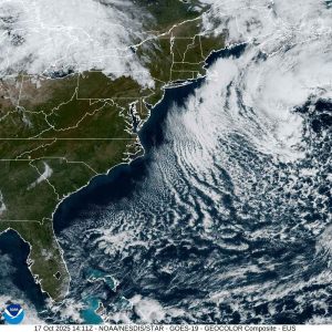
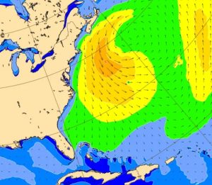
Small but persistent mid period ENE trending E swell is reaching the area, with buoy 41110 around 3 ft at 10–11 s. This is associated with the same storm system that impacted the area last weekend/earlier this week and has since moved NE and ultimately back into our swell window in the NW Atlantic. Meanwhile, high pressure will settle over the area through Friday and Saturday, leading to overall favorable winds and conditions. The high pressure system shifts offshore Sunday ahead of the next cold front, yielding increasing SSW/S winds and deteriorating conditions.
The end result of this will be plenty of knee- to waist-high surf the next few days but I would not be surprised to see inconsistent bigger sets at standout breaks during select tide cycles. Keep an eye on 41110 for swell above 2 ft at 9–10 s as a threshold for that to occur. Winds will be best on Saturday but a light side/onshore texture is probable during the PM hours. Sunday morning also should have a decent wind window but look for stronger S winds to impact conditions as we move through the morning and afternoon as the next front approaches.
As of 6:30 AM Friday, air temperatures across the area are the chilliest they have been since last spring (low to mid-40s). Water temperature at JMPN7 has dropped to 68. While plenty of great weather is expected this weekend, chilly nights will likely result in our water temps dropping a little further. Spring suits/short-arm fulls are still probably the call but no one will dock you for wearing a full suit, especially in the mornings.
Overall Best Weekend Window: Saturday late morning as the tide drops or Sunday morning at the more S wind-protected locations. Beware of predawn high tides: consider north of Mercer Pier or other high-tide spots if you want to catch the early good wind session this weekend.
The next front will push offshore Sunday night into Monday as weaker high pressure rebuilds from the deep south. This will also kick our offshore low out of the picture and unfortunately, this pattern means a trend towards smaller surf as we move through early to mid next week. That being said, it is worth keeping an eye on the NW Atlantic storm through the weekend. These systems have a tendency to outperform wave model guidance and I’m thinking there will still be some rideable waves around at least through Monday if you look around a bit, but look for it to ease to 1–2–3 ft (knee-thigh, maybe a little bigger at standout spots during best tides) before easing further through midweek. While we’ll see a brief period of N/NW winds behind the front on Monday, I’m not seeing anything suggesting they will be overly strong so conditions shouldn’t suffer all that much.
Another weak front and subsequent high pressure evolving through the SE states mid- to late next week doesn’t spell a ton of surf for the region. As a result, I’d suspect lots of minimal surf in the longboard/low-tide-only zone as we move into the second half of next week. That said, forecasts this far out are subject to change.
Next Week Bottom Line/Potential Best Days: Monday looks like the best day at this point. Keep expectations low, however, and watch for a brief period of NW/N winds in the morning to ease in the afternoon.
 Wavewire
 Pics
Pics CAMS
CAMS News
News Contact