
Wrightsville Beach Surf Outlook: November 7 – November 14, 2025
Issued 7:00 AM EDT, Friday, November 7, 2025. Note: This content will become less and less relevant with time.
By Mark Willis combined with Proprietary AI Surf Forecast Technology
- Friday: Small+ bumpy windswell. Biggest surf of the period, but poor conditions early; potential late-day improvement.
- Saturday: Cleaner but fading surf with W to SW winds.
- Sunday: Minor S windswell with building SSW bump.
- Early Next Week: Chilly, offshore, and very small to flat.
- Mid to Late Next Week: Little to no hope beyond longboard-only windows on favorable tides.
Discussion: The Weekend & Beyond
Today: Small+, Bumpy Windswell (Friday, 11/7)
High pressure sliding east of the Outer Banks is setting up moderate to strong onshore wind early this morning, alongside a bit of ENE windswell. Buoy 41110 ran a little higher than guidance (~4.6 ft @ 6s earlier), so waist+ peaks could be around at the best spots.
Expected Size: Knee–thigh high, with occasional waist+ peaks possible, especially the first half of the day.
Key Factor: Conditions are poor and bumpy early, but winds are expected to shift south and diminish later, so the late PM could be worth a look.
Saturday & Sunday: The Fade and Minor Bump
Saturday (11/8): Today’s windswell cleans up and drops as winds trend W to SW. Enough for bigger boards at the right spot/tide, but generally ankle–thigh and fading. The 9:00 AM high tide will make many morning spots too deep, so target the 3:35 PM low with tempered expectations unless you have a reliable high-tide option.
Sunday (11/9): A weak S windswell develops ahead of a front, bringing a minor bump in the ankle–knee zone. Expect increasing SSW (sideshore) winds and more texture/bump into the afternoon. Cleanest conditions are early.
Looking Ahead: Next Week’s Limited Potential
Early Week (Nov 10–11): A strong frontal system moves offshore and ushers in chilly high pressure, yielding strong NW (offshore) winds Monday–Tuesday. Surf: ankle-high or flat. Air temps only in the low 50s will help drop water temps further.
Mid to Late Week (Nov 12–14): High pressure to the south and low pressure over eastern Canada keep a net offshore flow and minimal surf Wednesday–Thursday. Expect only very small / longboard-only opportunities around favorable low tide windows at best. Not seeing meaningful improvement into next weekend at this lead time (always subject to change).
Bottom Line
The biggest surf is Friday but with poor early conditions; watch for a late-day wind shift. Saturday likely offers the cleanest conditions, but size is small and fading. Sunday brings a tiny S bump early before sideshore winds add bump.
Final Notes
Overall Best Forecast Window: Winds/conditions favor Saturday (small). For size alone, it’s Friday, though quality is suspect.
Water Temps: Very chilly weather early next week will likely drop water temps further. Suit accordingly.
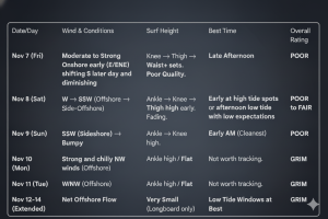
Wrightsville Beach surf forecast table for November 7-14, 2025.
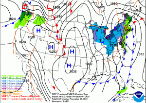
Weather map for Monday morning, November 10, showing strong and cold high pressure building in behind a series of cold fronts. This pattern unfortunately does not bode well for our surf forecast.
 Wavewire
 Pics
Pics CAMS
CAMS News
News Contact