
Wrightsville Beach Surf Outlook: November 28 – December 5, 2025
Issued 6:30 AM November 28. Note: This content will become less and less relevant with time.
By Mark Willis
Overall Summary:
- Cold Friday and Saturday with very minimal surf
- Warmer but still small surf Sunday
- Stronger windswell early week with Tuesday looking best
- Smaller but likely rideable waves for big boards mid to late week
Forecast Discussion
Today through Sunday (11/28–11/30): Minimal Surf; Cold Fri/Sat; Warming Sun
Much colder air moves into the region this morning as Canadian high pressure settles in. The chilly NW winds keep things flat on Black Friday. Winds trend NE on Saturday with only minor windswell developing. By Sunday, a mix of small SE swell and light winds emerges as high pressure shifts offshore, allowing temperatures to warm.
Friday (11/28): Near flat surf with cold NW winds.
Saturday (11/29): Trace NE/E windswell and minor SE mix, mostly ankle to shin high with occasional knee-high peaks. Semi-bumpy with N/NE winds shifting E.
Sunday (11/30): Small SE swell mix in the ankle- to shin-high range. Winds turn S with warmer temperatures.
Water Temp Note: Archived JMPN7 data modeled through an AI LLM suggests water temperatures may drop to around 57°F by Sunday morning. Fullsuit + boots recommended.
Looking Ahead: A Bit More Surf Potential Early to Mid Week
A front moves offshore Monday before the next storm system approaches from the Deep South. This setup brings building mixed windswell early in the week that gradually cleans up and eases midweek. High pressure returns later in the week with only minor SE swell and local windswell continuing.
Early Week (Dec 1–2): Stronger windswell builds. Mostly knee-high surf Monday morning increasing to thigh–waist high late day with bumpy NE–E winds. Tuesday brings stronger SE windswell in the waist–shoulder high range with larger sets possible. Morning conditions look choppy with SE–S winds, but an afternoon or early evening clean-up is possible as winds trend westerly. Rain may influence local winds early.
Mid to Late Week (Dec 3–5): Windswell eases into the 1–2 ft+ range (shin–knee–thigh high) Wednesday with occasional early waist-high sets. Winds shift NW then NE/E but remain modest, keeping conditions semi-clean to semi-bumpy. A small SE swell persists later in the week with a few slightly larger sets possible around the better sandbars during favorable tides. Winds look best Thursday and may trend onshore Friday behind another front.
Final Notes
Overall Best Forecast Window: Tuesday remains the standout day with the strongest and most organized SE/ESE swell. Smaller but rideable longboardable waves are possible mid to late week. Continued cooling of water temps likely through the weekend.
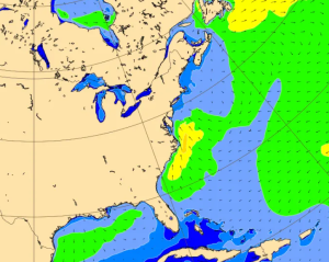
ECMWF Wave Heights for Tuesday afternoon, showing elevated SE/S swell off the coast as low pressure moves through the region.
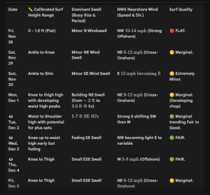
Latest WB Surf Forecast table enhanced by AI. While Tuesday is the day to keep an eye on, it will be worth watching the entire midweek period for smaller but still rideable ESE/SE swell.
 Wavewire
 Pics
Pics CAMS
CAMS News
News Contact