
Wrightsville Beach Surf Outlook: May 8–May 15, 2026
Issued 6:30 AM May 8. Note: Forecast based on early Friday morning data. While broad patterns usually hold, forecast shifts occur—verify conditions before heading out.
Fri–Sat: Small Windswell Mix, Best in Mornings
Sun: Still Small but Clean with AM Offshores
Mon–Tue: Minor Surf; Watching Front
Mid-Late Week: A Modest Midweek Bump; Overall Minor Surf Persists
Quality Legend: 🟢 = Fun/Clean; 🟡 = Marginal to Fair at Best; 🔴 = Poor/Blown Out.
Vibe Legend: ✨=Clean; 🧘=Small; 🌬️=Breezy; 📉=Cooler; 🌅=Sunrise/Early Window; 🪵=Loggable; 😎=Warm; 📈=Building; ❓=Uncertain.
Today through Sunday (5/8–5/10): Small Mixed Windswell; Cleanest Sunday AM
High pressure builds in behind a cold front today and moves east of the Outer Banks by Saturday. This pattern sets up a minor ENE windswell that rotates more SE on Saturday, mixing with trace underlying swell. Expect mostly 1–2’ (knee high) surf both days, with only slightly bigger sets for standout spots. Small SE/S windswell lingers on Sunday.
Winds: Expect a brief period of N winds Friday morning that trend light onshore during the afternoon. Saturday morning sees light S winds increasing out of the SSW through the afternoon, leading to increasingly bumpy/sideshore conditions. Sunday is the standout for quality with lighter WSW winds in the morning providing cleaner faces before S winds add texture in the afternoon.
Tides: Morning low tides this weekend combined with better early winds make the mornings the prime time to break out the bigger boards.
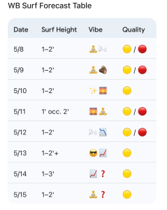
- 5/8 (Friday): 1–2′ windswell mix. High 71°F. Early N winds trend light onshore PM. Quality: 🟡 / 🔴.
- 5/9 (Saturday): 1–2′ SE windswell mix. High 76°F. Best AM; breezy SSW afternoon. Quality: 🟡 / 🔴.
- 5/10 (Sunday): 1–2′ cleaner SE/S mix in the AM. High 79°F. WSW winds / Best Shape. Quality: 🟡.
Looking Ahead: Frontal Shifts and Midweek Southerly Bump
More small S/SE windswell continues Monday, mostly in the shin-to-knee range with rare thigh-high peaks. Winds look light offshore in the morning before trending North in the afternoon behind another front. Post-frontal high pressure leads to minor 1–2’ ENE windswell on Tuesday, though a few slightly bigger, short-period peaks aren’t out of the question.
High pressure pushes offshore through Wednesday and Thursday, leading to small S/SE windswell in the knee-to-thigh high zone. Models are hinting at slightly stronger SE/S windswell later Wednesday into Thursday, with potential for some waist-high (3′) sets, but confidence is low this far out. By the end of next week, expect small NE/E windswell as the next front moves offshore.
- 5/11 (Monday): 1′ occ. 2′ minor surf. High 79°F. Clean early; N wind shift PM. Quality: 🟡 / 🔴.
- 5/12 (Tuesday): 1–2′ ENE windswell. High 71°F. Breezy & Cooler. Quality: 🟡 / 🔴.
- 5/13 (Wednesday): 1–2′+ building S windswell. High 75°F. Quality: 🟡.
- 5/14 (Thursday): 1–2–3’ S/SE mix. High 76°F. Watching for a modest bump. Quality: 🟡.
- 5/15 (Friday): 1–2′ minor ENE windswell. Quality: 🟡.
Final Thoughts
Minimal surf the next few days, with Sunday morning looking like the cleanest window of the period for the bigger boards. No significant wave events are on the horizon for next week, so keep expectations low and volume high.
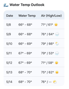
Updated WB water temp forecast: This temperature range is open to your wetsuit (or no wetsuit) preference, but typically a short arm full/spring suit is worth considering.
 Wavewire
 Pics
Pics CAMS
CAMS News
News Contact