
Wrightsville Beach Surf Outlook: May 29 – June 5, 2026
Issued 6:30 AM May 29. Note: Forecast based on early Friday morning data. While broad patterns usually hold, forecast shifts occur—verify conditions before heading out.
Fri-Sun: Small Mix of ESE Swell & Local Windswell; Strongest/Bumpy Sunday
Mon-Tue: Cleaner Leftovers Monday; Renewed N/NE Winds but Small Tue
Mid/Late Week: Midweek Offshore Low Worth Watching; Summer Mix Follows
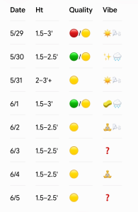
Legend: 🟢Fun/Clean | 🟡Marginal to Fair at Best | 🔴Poor/Choppy | ☀️Sunny | ✨Clean/Glassy | 🧘Small/Fun | 🌬️Breezy | 🧽Cleaner Leftovers | 🌧️Showers | ❓Uncertain
Weekend (5/29–5/31): Small Mix of ESE Swell and Local Windswell; Strongest Sunday
Lingering SE swell is mixing with some new ENE windswell behind a cold front to produce mostly knee-to-thigh high surf across the area this Friday morning, but buoy readings are indicative of waist-high sets around for better spots. Winds today will be NE to E trending SE/S late today into the evening. Overall expect bumpy to semi-bumpy conditions.
A secondary cold front approaches Saturday and eventually moves south of the area by late Saturday afternoon/evening. Overall this will lead to lighter winds and cleaner knee-to-thigh high surf, but look for a surge of NE winds by evening behind the front. Showers may impact winds and conditions at times, especially the afternoon.
Sunday looks cooler along with a bit more (2-3’+) ENE windswell. Conditions look bumpy especially early with ENE winds, but look for winds to back off some late. Weekend tides will be HIGH in the mornings and early evenings, and LOW around lunchtime.
- 5/29 (Friday): 1.5–3′ (Knee-to-thigh high, with waist-high sets). High 82°F. Bumpy to semi-bumpy as NE/E winds trend SE/S late. Quality: 🔴/🟡.
- 5/30 (Saturday): 1.5–2.5′ (Knee-to-thigh high). High 83°F. Lighter winds offer cleaner morning through afternoon surf before a late-day NE surge hits behind a secondary front. Quality: 🟢/🟡. Showers possible esp. PM.
- 5/31 (Sunday): 2–3’+ (Thigh-to-stomach high) ENE windswell. High 74°F. Bumpy early under ENE winds, improving slightly late. Quality: 🟡.
Looking Ahead: Cleaner Leftovers Monday. Midweek Low Worth Watching.
Cleaner conditions are expected Monday although the surf will likely drop a bit, with mostly knee-to-thigh high surf and occasional waist-high sets. Another front and post-frontal high pressure brings more N/NE winds for Tuesday, but at this point we aren’t expecting much more than knee-to-thigh high surf.
There is uncertainty for the midweek timeframe, with some models suggesting low pressure will develop offshore with perhaps slightly stronger ENE windswell/swell. Overall we expect a gradual return to a more summer-like pattern later next week/weekend which could mean a small but rideable SE swell and local S windswell mix. I’ve capped it at knee-thigh high for now Thursday and Friday of next week, but this timeframe is worth watching as the midweek low pressure evolves and gradually transitions to a summer SE swell mix. Note we’ll be trending to a morning/evening low tide by later next week, along with better winds in the mornings.
- 6/1 (Monday): 1.5–3‘ (Knee-to-thigh high, occ. waist-high sets). High 79°F. Cleaner leftovers with favorable winds esp. in the morning. S winds add bump afternoon. Quality: 🟢/🟡. Chance of showers and tstms.
- 6/2 (Tuesday): 1.5–2.5′ (Knee-to-thigh high). High 79°F. N/NE winds. Quality: 🟡.
- 6/3 (Wednesday): 1.5–2.5′ surf, possibly slightly bigger. High 79°F. Midweek offshore low watch; track dictates wind/swell changes.: Quality: 🟡.
- 6/4 (Thursday): 1.5–2.5′ summer mix lines. High 78°F. Capped at knee-thigh high for now, but keeping an eye on offshore low evolution. Best winds/conditions early. Quality: 🟡.
- 6/5 (Friday): 1.5–2.5′ summer mix lines. Looking like small, rideable SE swell mixed with local S windswell. Best winds/conditions early. Quality: 🟡.
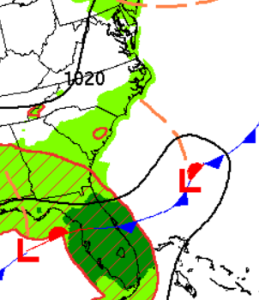
Watching low pressure off the SE and then Mid Atlantic Coast Around Mid-week.
Final Thoughts
Small mix of SE swell and ENE windswell gradually eases but cleans up Saturday. A renewed surge of ENE windswell brings slightly stronger surf on Sunday. This cleans up and drops Monday when it is worth watching. Uncertainty mid to late week with potential offshore low pressure, but trending towards small (but rideable) SE/S mix later next week.
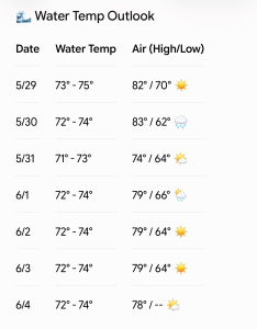
Updated WB water temp forecast. Certainly trunkable at this point.
 Wavewire
 Pics
Pics CAMS
CAMS News
News Contact