
Wrightsville Beach Surf Outlook: May 22–May 29, 2026
Issued 6:30 AM May 22. Note: Forecast based on early Friday morning data. While broad patterns usually hold, forecast shifts occur—verify conditions before heading out.
Memorial Day Weekend: Lingering SE/ESE Swell. Best Winds Fri/Mon AM.
Tue-Wed: Persistent SE/ESE Swell. Best Winds Early but Watching Tides.
Late Week: Fading ESE Swell; Some Long Term Potential
Quality Legend: 🟢 = Fun/Clean; 🟡 = Marginal to Fair; 🔴 = Poor/Blown Out.
Vibe Legend: ✨Clean/Glassy | 🧘Small/Fun | 🌬️Breezy | 🌅Sunrise | 📈Building | 🌧️Wet | ❓Uncertain
Memorial Day Weekend (5/22–5/24): Lingering Small/Fun Sized ESE Swell. Occasional Weekend S/SE Wind Issues
A well positioned offshore high pressure system combined with its recent interaction with troughiness to its south continues to pump out small to fun sized ESE swell for the area. This is producing ~3ft at 8-10s swell on buoy 41110, translating to thigh-stomach high surf across the area. Inconsistent bigger sets continue to be observed. Winds are light this morning so conditions are glassy. Expect S winds to add some bump this afternoon.
The offshore high pressure system will strengthen its influence over the area through the weekend as a weak front in our vicinity gradually dissipates. Overall more thigh-waist high surf is expected out of the ESE/SE for the weekend, with inconsistent plus sets possible. While there should still be a window of decent winds early in the mornings (but not as good as the last couple of days), this pattern will likely lead to a somewhat earlier enhancement of S/SE flow over the area by mid morning into the afternoons. In addition, winds/conditions may vary at times around scattered showers/thunderstorms. Tides will still be low in the mornings through the weekend when the best winds are likely, but again we do expect SE/S wind issues to develop earlier than they have been through the day.
For Memorial Day, there is some indication the winds will be lighter SW in the morning (vs. S/SE Sat/Sun), which should lead to a period of cleaner AM conditions.
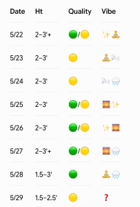
- 5/22 (Friday): 2–3’+ (Thigh to stomach high) ESE swell with inconsistent waist-high sets. High 80°F. Light NW winds this morning trend S 6-11 mph PM. Showers/t-storms may impact winds/conditions at times. Chance: 60%. Quality: 🟢 / 🟡.
- 5/23 (Saturday): 2–3′ ESE/SE swell. High 83°F. Light S/SE winds becoming S winds 7-11 mph and bumpier in the PM. Low risk of a PM shower/t-storm. Chance: 20%. Quality: 🟡.
- 5/24 (Sunday): 2–3′ ESE/SE swell. High 82°F. Best early before S winds 6-13 mph add chop. Showers/t-storms may impact winds/conditions at times. Chance: 80%. Quality: 🟡.
- 5/25 (Memorial Day): 2–3′ ESE/SE surf. High 84°F. Cleaner AM with lighter SW winds, bumpier PM. Lingering showers/t-storms possible. Chance: 50%. Quality: 🟢 / 🟡.
Looking Ahead: Lingering ESE Swell; Better AM Winds. Fading Late Week.
Overall more 2-3’ surf on the face out of the ESE/SE is expected through mid next week. Best winds in the morning (light SW) will trend S/SSE in the afternoon and increase, along with increasingly bumpy conditions.
The offshore high pressure pattern is expected to gradually break down later next week. While this could lead to even better winds especially in the morning, it will also likely lead to a gradual drop in the persistent SE/ESE swell through Thursday and Friday. Another thing to consider is tides will gradually trend to a morning high, which will impact many spots through mid/late next week. There is also some model indication that we could see a front towards next weekend with renewed windswell potential, but confidence is low on the details.
- 5/26: 2–3‘ ESE/SE swell. High 85°F. Best winds early but start watching tides. Afternoon showers/t-storms possible. Chance: 40%. Quality: 🟢 / 🟡.
- 5/27: 2–3’+ ESE/SE swell. High 84°F. Favorable AM winds but trending to an early high tide. Showers/t-storms may impact winds/conditions at times. Chance: 60%. Quality: 🟢 / 🟡.
- 5/28 (Thursday): 1.5–3′ slowly fading SE swell. High 82°F. Better winds overall but watch for morning high tide. Showers/t-storms may impact winds/conditions at times. Chance: 60%. Quality: 🟢.
- 5/29 (Friday): 1.5–2.5′ residual mix. Watching next front for windswell potential. Quality: 🟡.
Final Thoughts
Best days of Memorial Day weekend look today (Friday morning) and Monday morning as SE/ESE swell lingers. Small to fun sized SE/ESE swell lingers into mid next week with best conditions in the mornings. This is a nice pattern we’ve been in, so take advantage of it. Note morning high tides will impact many spots as we move into mid next week.
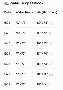
Updated WB water temp forecast. Certainly trunkable at this point to a short arm/spring suit max.
 Wavewire
 Pics
Pics CAMS
CAMS News
News Contact