
Wrightsville Beach Surf Outlook: June 25 – July 2, 2026
Issued 6:30 AM June 25. Note: Forecast based on early Thursday morning data. While broad patterns usually hold, forecast shifts occur—verify conditions before heading out.
Thu-Sun: Small ESE Swell & Windswell Mix; Increasingly Hot
Mon-Wed: Potential Small Windswell Enhancement With Front
Looking Ahead: Long-Range Charts Hint at Standard Summer Surf Returning Heading Towards July 4th Weekend
Best Windows of Forecast: Sunday Morning is Cleaner; Watching Tue-Thu for Slightly More Windswell
Legend: 🟢 Fun/Clean | 🟡 Marginal/Fair | 🔴 Poor/Choppy | ✨ Clean/Glassy | 🧘 Small/Fun | 🌬️ Breezy | 🌅 Sunrise/AM Window | 📈 Building/Changing | 👀 Keep an Eye On It | ❓ Uncertain
(Note: Split quality colors represent AM / PM sessions)
Thursday Through Weekend (6/25–6/28): Small Swell & Local Windswell Mix
Surf
Small ESE swell is reaching the area (2ft at 8s on buoy 41110) and will generally hold through the weekend while mixing with small local windswell. Expect mostly knee to occasionally thigh-high surf under increasingly hot summer weather.
Winds
- Thursday: A weak front south of the area keeps winds light onshore, increasing slightly to SE later for semi bumpy conditions.
- Friday: Front dissipates into inland troughing, offering light SW/WSW winds and clean morning surf before picking up out of the south at 9–14 mph (gusts to 20 mph) with afternoon chop.
- Saturday: Stronger morning SW winds bring sideshore texture before heavy afternoon S/SSW breezes blow things out, with gusts pushing up to 21 mph. Scattered afternoon showers/storms may impact winds/conditions.
- Sunday: Localized troughing brings lighter, more variable morning winds and cleaner surface shapes. Afternoon sea breeze is less pronounced, but watch for scattered afternoon showers/storms which may impact winds/conditions.
Tides
Early morning and early evening high tides dominate the weekend, so choose morning spots wisely. Late morning to early afternoon dropping tide with higher-volume boards before afternoon winds fully ramp up is worth considering, but keep expectations low.
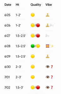
- 6/25 (Thursday): 1–2′ (Knee-high, occasional thigh sets). Light east winds trend SE and increase a bit later with semi bumpy conditions. Quality: 🟡.
- 6/26 (Friday): 1–2′ (Knee-high, occ. Thigh high sets). Cleanest early under light SW/WSW winds before south winds pick up to cause afternoon chop. Quality: 🟢 / 🟡.
- 6/27 (Saturday): 1.5–2.5′ (Knee to thigh high). Textured SW morning winds give way to blown-out afternoon sessions under heavier S/SSW breezes. Watch the morning high tide. Quality: 🟡 / 🔴.
- 6/28 (Sunday): 1.5–2.5′ (Knee to thigh high). Likely best weekend window. Lighter, variable morning winds provide clean conditions, followed by a less pronounced afternoon sea breeze. Watch the morning high tide. Quality: 🟢 / 🟡.
Looking Ahead: Front Watch for Minor Windswell Upgrades
A slow-moving front approaches early next week, potentially drifting just south of the region by mid-week. While late June fronts carry high forecast uncertainty, consensus favors light-to-moderate onshore flow (NE trending E/SE) Monday through Wednesday. Expect a small mix of ESE swell and local windswell. If the front successfully pushes south, post-frontal high pressure could enhance the windswell enough to deliver waist-high or so peaks Tuesday and Wednesday, potentially lingering into Thursday. High tides shift later into the morning, pushing low tides later in the afternoon.
Longer-range charts hint at standard summer SW/S winds re-establishing late next week nearing the July 4th weekend. This would lead to a small, longboardable ESE swell/S windswell mix with the best conditions early. Favorable early morning low tides approaching the holiday weekend offer a silver lining.
- 6/29 (Monday): 1.5–2.5′ (Knee to thigh high). Light-to-moderate onshore flow (NE to E). Quality: 🟡.
- 6/30 & 7/01 (Tue-Wed): 2–3′ (Knee to waist high). Small ENE windswell mix under light-to-moderate onshore winds. Conditions stay semi bumpy as we monitor the front. Quality: 🟡.
- 7/02 (Thursday): 1.5–3′ (Knee up to waist high). Morning tides are gradually improving. Expecting gradual return to summer-like small SE/S swell heading into holiday weekend. Quality: 🟡.
Tropical Update
The tropics are quiet at this time.
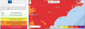
Increasing heat risk for the weekend. Monitor this NWS product here.
 Wavewire
 Pics
Pics CAMS
CAMS News
News Contact