
Wrightsville Beach Surf Outlook: Jan 9–16, 2026
Issued: 7:30 AM Jan 9
Note: This forecast is based on data from 7:30 AM Friday. While broad patterns usually hold, the forecast can shift. Please verify local conditions before heading out.
By Mark Willis
Key Points
- Today: Tiny surf
- Weekend: Gradually developing small S/SE windswell, cleaning up Sunday
- Early Week: Cooler and small scale
- Mid to Late Week: Minimal, but watching late week
WB Surf Forecast Table
Quality Key: Green = Fair/Good, Yellow = Marginal, Red = Poor/Flat
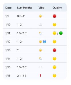
Today through Sunday (1/9–1/11): Minor Friday and Saturday, Slightly Stronger Sunday
Buoy 41110 is checking in around 1 to 2 feet at 5 seconds this morning. As a result, the surf is hovering in the shin-high range today. High pressure currently positioned near Cape Cod will slide offshore through the weekend as the next cold front approaches from the west.
This setup allows a touch more southerly windswell to develop Saturday, though increasing SSW winds will introduce sideshore texture. A little more S windswell is expected Sunday, along with a W to NW wind shift through the afternoon. This should help clean things up briefly before surf size and temperatures both trend downward.
Friday 1/9: Shin-high traces. Light NE winds becoming S at 5 to 10 mph with sideshore flow. High 69°F.
Saturday 1/10: Traces early, with 1 to 2 foot knee-high S/SE windswell developing through the afternoon. Increasing SSW winds keep conditions textured. High 72°F.
Sunday 1/11: 1.5 to 2.5 foot knee to thigh-high S/SE windswell. Occasional waist-high sets possible at standout spots. Winds shift W to NW through the day with surf dropping toward sunset. High 67°F but falling through the afternoon.
Looking Ahead: Small Surf into Next Week
Monday (1/12) turns cooler with a high near 50°F, along with only a minor amount of NE to ENE windswell in the 1 to 2 foot zone on the face, topping out around knee high. Tuesday remains minimal under high pressure with a high near 56°F.
Surf remains small scale into Wednesday and Thursday, though there is some potential for additional NE to ENE windswell as low pressure pushes northeast just offshore. Earlier model runs were more aggressive, but the latest guidance for Friday has scaled things back to around 2 feet, plus or minus, with high uncertainty as the track and intensity of the system remain volatile.
Final Thoughts
Sunday is worth monitoring for a modest bump in size as winds shift offshore, but expectations should remain low. Late next week is also worth watching, though confidence remains limited.
Unfortunately, it looks like slim pickings overall this week. If you happen to spot a rideable wave on the WBLive cam, it may be worth a paddle.
 Wavewire
 Pics
Pics CAMS
CAMS News
News Contact