
Wrightsville Beach Surf Outlook: Feb 27–March 6, 2026
Issued 6:45 AM Feb 27. Note: Forecast based on early Friday morning data. While broad patterns usually hold, forecast shifts occur—verify conditions before heading out. By Mark Willis
- Today/Friday: Small+ SSE Swell; Rainy
- Weekend: Minor SE Swell; Warmer with Increasing Sun
- Early Week: Stronger ENE Windswell Pulse; Bumpy
- Mid-Late Week: Improving Conditions with Slowly Dropping Size
Quality Key
- Green = Fair/Good
- Yellow = Marginal
- Red = Poor/Flat
Vibe Legend
🪵 = Loggable Window; 🫧 = Clean Faces; 📈 = Building; 📉 = Fading; 🌪️ = Bumpy/Windy; 🧼 = Cleaning Up; 🧘 = Small/Relaxed; 🏖️ = Beach Day.
Today through Sunday (2/27–3/1): SSE Swell Fades; Small Longboard Waves
A slow-moving frontal system will sag just south of the area today. This will bring periods of rain and small to locally fun-sized SSE swell, generally in the knee-to-waist high zone. Conditions will be best in the morning with light and variable winds, becoming NE through the afternoon and adding a bit of texture/bump for many spots. Patchy fog this morning may impact visibility at times.
Overall smaller (~knee high) surf is expected for the weekend, but there will be occasional longboard waves (up to thigh high sets) with small SE swell lingering. Light N winds become more variable during the day on Saturday. Sunday morning sees light offshore winds that trend SSW to S in the afternoon with a weak pressure pattern intact. Increasing sunshine with temps in the mid-60s this weekend—it could be worse.
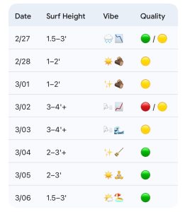
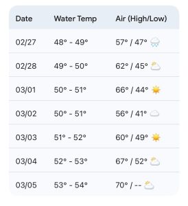
- 2/27 (Friday): 1.5–3′ (Knee to Waist High) SSE swell. High 57°F. Rainy; light winds becoming NE. Clean becoming textured in the PM. Quality: 🟡 / 🔴.
- 2/28: 1–2′ (Ankle to Knee High) minor SE swell. High 62°F. Gradually clearing; light N to NE winds. Semi-clean to lightly textured surf. Quality: 🔴.
- 3/01: 1–2′ (Ankle to Knee High) small leftovers. High 66°F. Mostly sunny; light offshore morning winds becoming S. Clean early, bumpier in the afternoon. Quality: 🔴.
Looking Ahead: Stronger ENE Windswell Early Week; Improving Mid-Week
A stronger cold front will push south of the area Sunday night, followed by cooler high pressure and NE winds. This drives a stronger windswell for Monday and Tuesday, pushing heights into the 3–4’+ zone, with slightly bigger sets not out of the question. Conditions will be bumpy with strong NE winds on Monday, with the exception of select protected spots. Winds relax some Tuesday, but it will still likely be at least semi-bumpy then.
While the swell will fade mid-to-late week, there is potential for small to fun-sized surf through Friday. High pressure will move offshore, allowing warmer weather and periods of favorable winds (especially in the mornings). Wednesday through Friday (3/4–3/6) are the standout windows for quality, rated 🟢 with surf generally in the 2-3’ range and conditions best in the mornings. Bigger sets are expected midweek before those become fewer and further between later week.
- 3/02 (Monday): 3–4’+ (Waist to Shoulder High) building ENE windswell. High 56°F. Bumpy with NE winds. Quality: 📈 / 🌪️.
- 3/03: 3–4’+ (Waist to Shoulder High) ENE windswell. High 60°F. Semi-bumpy with diminishing NE to E winds. Quality: 🟡.
- 3/04: 2–3’+ (Thigh to Stomach High) cleaning up ESE swell. High 67°F. Quality: 🧼 / 🫧. Best winds in the morning; chest-high sets possible for top spots.
- 3/05: 2–3′ (Knee to Waist High) ESE swell. High 70°F. Quality: 🟢. Best in the morning.
- 3/06: 1.5–3′ (Knee to Waist High) ESE swell. High 70°F. Quality: 🧘 / 🪵. Sunny and relaxed; best in the morning.
Final Thoughts
The best opportunities for rideable surf this weekend will be on lower tides with longboards as the sunshine returns. Early next week brings more significant size but messier conditions, followed by an extended window for small/fun-sized but rideable surf Wednesday through the end of the week as conditions clean up and air temps remain mild
 Wavewire
 Pics
Pics CAMS
CAMS News
News Contact