
Wrightsville Beach Surf Outlook: Feb 20–27, 2026
Issued 6:45 AM Feb 20.
Note: Forecast based on early Friday morning data. While broad patterns usually hold, forecast shifts occur—verify conditions before heading out.
By Mark Willis
Today: Small SSE Windswell; Warm
Weekend: Minor Windswell; Winds Shifty (Cleaner Sun)
Early Week: Colder with Small Surf
Mid-Late Week: Occasional Longboard Waves; Windswell Potential Later Week
WB Surf Forecast Table
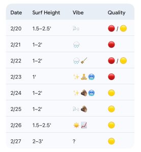
Quality Key: Green = Fair/Good, Yellow = Marginal, Red = Poor/Flat
Vibe Legend: 🪵 = Loggable Window; ✨ = Clean Faces; 📈 = Building; 📉 = Fading; 💨 = Bumpy/Windy; 🧼 = Cleaning Up; 🧘 = Small/Relaxed; ❓ = Uncertainty.
Today through Sunday (2/20–2/22): Overall Small Windswell
A cold front will approach the area today and gradually slide south, stalling over South Carolina through Saturday. This pattern produces mostly knee up to thigh high S windswell. Winds today stay in the SSW/SW range before trending more NE to E on Saturday as the front sits to our south.
Low pressure develops along the front Sunday and eventually lifts NE through the Outer Banks by the evening. While this weather pattern brings rain, it won’t provide much surf; expect mostly 1–2’ surf to persist along with developing W to NW winds and cooler air moving in Sunday afternoon and night. Sunday (2/22) is rated 🧼 / 🪵 as the wind shift may provide a brief window of improved shape despite the small size.
Friday (2/20):
1.5–2.5′ (Knee to Thigh High) S windswell. High 70°F. Sideshore with steady SW winds. 💨
Saturday (2/21):
1–2′ (Ankle to Knee High) minor energy. High 62°F. Possible showers with light NE to E winds. 🧘
Sunday (2/22):
1–2′ (Ankle to Knee High) surf. High 57°F. Rain clearing with developing W/NW winds and cooler air moving in/dropping temps later day. 🧼
Looking Ahead: Colder Early Week; Minor E Swell & Building S Windswell Late Week
Cold high pressure builds into the area early next week. Monday looks minimal with associated offshore NW winds. Expect only a modest amount of mid-period ENE/E swell for Tuesday and Wednesday.
Winds are forecast to be offshore from the NW to W on Tuesday (2/24), keeping conditions clean throughout the day. On Wednesday (2/25), winds increase from the SW again. This will provide a clean morning window on Wednesday, but conditions will likely become textured by the afternoon as the SW flow develops.
Monday (2/23):
1′ (Ankle High) trace energy. High 48°F. Clean faces with NW winds. ✨
Tuesday (2/24):
1–2′ (Knee High) minor E swell. High 48°F. Offshore NW winds; clean all day. ✨
Wednesday (2/25):
1–2′ (Knee High) minor E swell. High 58°F. Clean morning (W/SW winds); getting textured through the day as SW winds increase. 🧘
Thursday (2/26):
1.5–2.5′ (Knee to Thigh High) building S windswell. High 62°F. 📈
Friday (2/27):
2–3′ (Knee to Waist High) windswell mix. High 62°F. Uncertainty exists given the range of model solutions for the late-week front. ❓
Final Thoughts
Overall small surf for the weekend and much of next week, so think low tide longboard waves when the winds are favorable (Sunday and early/mid-week). A little more windswell possible later next week. Cold weather returns by early next week before warming thereafter. Water temps at JMPN7 are 47.8°F and may rise slightly today/tomorrow before dropping a little early week with the cold weather.
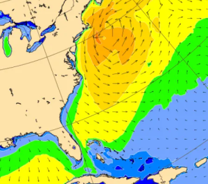
ECMWF wave model projection for Monday 2/23: Low pressure will enhance wave heights off the Mid Atlantic/NE States early next week, but most of the swell will bypass our area, unfortunately.
 Wavewire
 Pics
Pics CAMS
CAMS News
News Contact