
Wrightsville Beach Surf Outlook: Feb 13–20, 2026
Issued 6:45 AM Feb 13.
Note: Forecast based on early Friday morning data. While broad patterns usually hold, forecast shifts occur—verify conditions before heading out.
By Mark Willis
- Today: Small E Swell; Modest NE Winds Developing
- Weekend: Small Saturday; Building South Windswell Later Sunday
- Early Week: Enhanced Windswell Persists; Moderate NE Winds Mon Diminishing Tue
- Mid-Late Week: Trending Smaller with Favorable Winds; Warmer
WB Surf Forecast Table
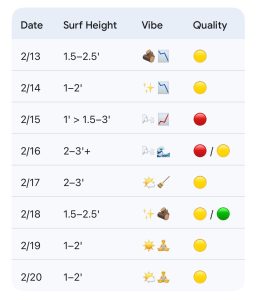
Quality Key: Green=Fair/Good, Yellow=Marginal, Red=Poor/Flat
Vibe Legend: 🪵=Log/Mid-length Window; ✨=Clean Faces; 📈=Building; 📉=Fading; 🌬️=Bumpy/Windy; 🧹=Cleaning Up; 🌊=Mixed Energy; 🧘=Small/Relaxed.
Today through Sunday (2/13–2/15): Overall Small; Watching Sunday Windswell
A small E swell is registering on the local buoy network this morning. Overall, expect mostly knee-high surf today with thigh-high sets at better spots—with semi-clean conditions early becoming semi-bumpy as light NW/N winds trend more NE through the day. Winds diminish Saturday as high pressure moves overhead, providing fairly clean conditions but small surf at knee-high or less. Tides will be low in the late morning/early afternoon today (~10:50 AM) and tomorrow (~11:30 AM), which will likely be the only window for the bigger boards at most spots.
A frontal system approaches Sunday, bringing gradually increasing SE to S winds. Bumpy windswell is expected to build from knee-high or less in the morning to the knee up to waist-high zone by sunset, accompanied by rain moving in later in the day.
- 2/13: 1.5–2.5′ (Knee occ. Thigh High) mixed swell. High 52°F. Light NW/N winds becoming NE, and semi clean becoming semi bumpy conditions.
- 2/14: 1–2′ (Ankle to Knee High) minor surf. High 57°F. Cleaner and likely best a couple hours either side of low tide (~11:30).
- 2/15: 1′ > 1.5–3’ (Knee high or less early building to thigh/waist high late) developing S windswell. High 60°F. Increasing SE/S winds, bumpy and rain moving in during the PM.
Looking Ahead: Mixed Windswell Pulse; Smaller but Cleaner Mid-Week
Low pressure and its attached fronts move offshore early next week. This should keep mixed-direction windswell/swell in the knee-to-waist high zone with bigger sets possible Monday. Moderate NE winds will lead to bumpy and windy conditions on Monday and early Tuesday. However, there is potential for winds to diminish later Tuesday as high pressure settles over the area, leading to a net improvement in conditions. Overall smaller surf is expected mid-to-late week but occasional clean/small longboard waves possible during best tides.
- 2/16 (Monday): 2–3’+ (Knee to Waist High w/ Plus Sets Possible) mixed windswell/swell. High 60°F. Bumpy and windy with moderate NE winds. Potential for semi-clean faces at protected spots.
- 2/17 (Tuesday): 2–3′ (Knee to Waist High) leftovers. High 62°F. Improving later in the day as winds diminish.
- 2/18–2/20: Trending smaller. Wednesday (2/18) is the standout window for quality (🟡 / 🟢) with surf in the 1.5–2.5′ range and cleaner conditions. The trend continues smaller (1–2′) through Friday. Confidence in surf heights is low for the end of the week, but temperatures will be notably warmer, reaching the upper 60s by Wednesday and Thursday.
Final Thoughts
The best opportunities for rideable surf this week remain the low tide windows today/Saturday for longboards and the expected cleanup window later Tuesday into Wednesday. The milder temperatures are a welcome change especially mid to late next week. Water temps should warm into the low 50s by later next week.
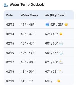
WB Water Temp Forecast. Warming next week!
 Wavewire
 Pics
Pics CAMS
CAMS News
News Contact