
Wrightsville Beach Surf Outlook: December 5–12, 2025
Issued 6:30 AM December 5
Note: This content will become less relevant with time.
By Mark Willis
-Chilly, dreary weather this weekend with small surf
-Best weekend day is Saturday (cleaner, but still small)
-Potential windswell bump early to mid week
-Below-normal temps continue into next week
Today Through Sunday (12/5–12/7) — Slowly Fading ESE Swell; Chilly & Dreary
We continue to see small but rideable ESE swell on the buoys, slightly outperforming wave model guidance. The longer periods will provide occasional rideable sets in the knee–thigh–waist high zone today before gradually easing through the weekend. Expect chilly, dreary conditions and periods of rain.
- Friday (12/5): 2–3 ft (knee–thigh with occasional waist peaks). Chilly, dreary, and rainy with N/NE winds producing semi-clean to semi-bumpy surf. Extremely high tide this morning hurts shape; better longboard waves open up this afternoon.
- Saturday (12/6): 2 ft+ (thigh high with inconsistent waist sets). Cleaner under NW winds around 10 kts. High tide issues early again; better waves appear as the tide drops in the afternoon. Chilly and dreary conditions persist.
- Sunday (12/7): 1–2 ft (knee high). Semi-clean with light NE–E winds 5–10 kts. Slightly drier and a touch warmer.
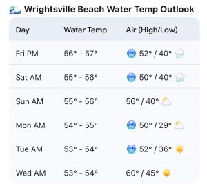
Water Temperature: Expected around 56°F by Sunday morning — full suit recommended, with a hood preferred.
Looking Ahead
Early Week (Dec 8–9)
Very small to start Monday morning, but a stronger NE → ENE/E windswell builds later Monday into Tuesday.
- Monday afternoon into Tuesday: 2–4 ft (thigh–chest high).
- Strong N–NE winds Monday will create poor conditions — seek protected spots.
- Tuesday sees improving winds later in the day.
- Air temperatures remain chilly.
Mid to Late Week (Dec 10–12)
Improving conditions possible Wednesday as windswell eases to 2–3 ft (knee–waist). Smaller surf likely Thursday and Friday, though confidence this far out is low.
Final Notes
Best Windows:
– Saturday afternoon on the lower tide (cleanest of the weekend, but still small).
– Tuesday/Wednesday (12/9–12/10) for an ENE windswell bump and improving winds.
Expect continued cooling in both water and air temperatures through next week.
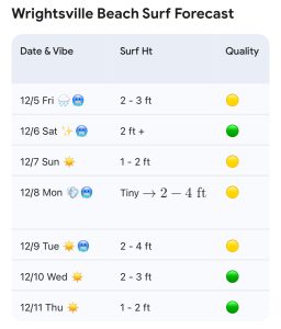
“Wrightsville Beach Surf Forecast. Green quality = Fair to Good/Clean Conditions, Yellow = Marginal, Red = Poor.”
 Wavewire
 Pics
Pics CAMS
CAMS News
News Contact