
Wrightsville Beach Surf Outlook: August 14 – August 20, 2026
Issued 6:30 AM August 14. Note: Forecast based on early Friday morning (8/14) data. While broad patterns usually hold, forecast shifts occur—verify conditions before heading out.
Weekend: Small Scale Surf
Mon–Wed: Minor SE Swell
Later Week: No Significant Swell but Watching Tropics
Best Windows of Forecast: Tue/Wed but Keep Expectations Low
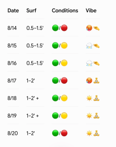
Legend: 🟢 Clean | 🟡 Fair/Semi Bumpy | 🔴 Poor/Choppy
Vibe Key: 🥵 Sweltering Heat | 🤏 Micro / Barely Rideable | ⛈️ Showers & Storm Risk | 🧘 Relaxed / Longboard Session | ☀️ Summer Sun
(Note: Split quality colors represent AM / PM sessions)
Friday Through Sunday (8/14–8/16): Weak Front & Small Summer Mix
Offshore high pressure and inland troughing set up mostly 0.5–1.5′ (ankle to knee high) S/SE windswell/swell mix on Friday. Slightly stronger peaks are possible late in the day as S winds pick up, but expect bumpier conditions in the PM hours (cleaner surf/lighter SW winds early).
A weak front will move into the area this weekend and overall set up lighter and more variable winds for the mornings both Saturday and Sunday before a moderate S wind develops each afternoon. Unfortunately, this doesn’t look to do much for our surf, with mostly 0.5–1.5′ (shin to knee high) surf expected.
Tide Timing: Tides will be high in the mid-to-late mornings this weekend (~9:00 AM Fri, ~10:00 AM Sat, ~10:50 AM Sun), which will be problematic for many spots when the winds are best. Overall, you’ll need to be quite selective the next few days to get a few waves in, but there will no doubt be a few longboard waves at select spots.
Looking Ahead: Minor SE Swell Trickle
Wave model guidance suggests we’ll see a trickle more of our standard summertime SE swell early to mid next week (especially Tuesday and Wednesday), but not much more than knee up to thigh high while mixing with minor local windswell mix. This is likely from distant Azores high/tropical wave interaction, but again it doesn’t look like much. No appreciable changes are expected into the second part of next week at this point.
Winds on Monday look best in the morning before an afternoon sea breeze gets on it. Another weak front may move into the vicinity around Tuesday/Wednesday which could set up a period of light to moderate NE to E winds, but confidence is low in this presently. Either way, winds and surface conditions will likely be best in the mornings. A return to light WSW/SW winds in the mornings and moderate+ SSW/S afternoon winds is expected by the second half of next week.
Tides: Tides will trend low in the mornings (and again just before dark) early to mid next week, with high tides around lunchtime. As a result, expect early mornings to be the time to target for higher-volume boards with low expectations.
🌀 Tropical Update
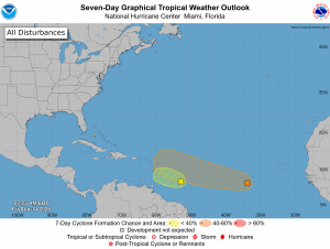
There are two tropical waves in the Tropical Atlantic between the Windward Islands and Africa. The one closest to the Caribbean has recently been downgraded to a low chance (30%) for development over the next 7 days, while the one further east has a medium chance (50%). The former may lead to a barely noticeable SE swell around Tuesday/Wednesday, while it is too far out to know if the system further out will do anything for us.

 Wavewire
 Pics
Pics CAMS
CAMS News
News Contact