
Wrightsville Beach Surf Outlook: April 3–April 10, 2026
Issued 6:45 AM April 3. Note: Forecast based on early Friday morning data. While broad patterns usually hold, forecast shifts occur—verify conditions before heading out.
Fri–Sat: Lingering Summer-Like SE/S Swell; Warm
Sunday: Increasing S Windswell ahead of Cold Front
Mon–Tue: Shifting Winds; Small Mix of Swells
Mid-Late Week: Building ENE Windswell; Potential Coastal Low (Low Confidence)
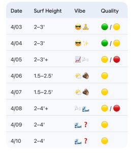
Quality Legend: 🟢 = Fun/Clean; 🟡 = Marginal to Fair at Best; 🔴 = Poor/Blown Out.
Vibe Legend: 🪵=Loggable Window; ✨=Clean Faces; 😎=Warm/Summer-like; 📈=Building; 🌊=Standard Surf; 🌬️=Bumpy/Windy; 🧘=Small/Relaxed; ❓=Low Confidence.
Today through Sunday (4/3–4/5): Lingering Summer-Like SE/S Swell; Warm
Summer-like, offshore high pressure will keep knee-waist high (2–3’) ESE/SE swell in the water through Friday and Saturday. This mixes with an increasing local S windswell Sunday ahead of the next cold front. Conditions will be best in the mornings the next few days before S winds add increasing bump/texture in the afternoons.
Note: Sunday afternoon will see considerably stronger SSW/S winds as the front approaches. Another thing to keep an eye on the next few days will be the late morning trending early afternoon high tides. As a result, the predawn/dawn session will be worth consideration, as the later day tide drop could be impacted by developing S winds.
- 4/03 (Friday): 2–3′ (Knee to Waist High) ESE mix. High 74°F. Best in AM. Quality: 🟢 / 🟡.
- 4/04: 2–3′ (Knee to Waist High) SE/S mix. High 76°F. Best early before S winds get on it.. Quality: 🟢 / 🟡.
- 4/05: 2–3’+ (Knee to Waist High +) building S windswell. High 76°F. Strong SSW winds PM. Quality: 🟡 / 🔴.
Looking Ahead: Shifting Winds, More Windswell Due Mid to Late Week Especially
The cold front will shift offshore Sunday night into Monday. This will allow winds to shift to the N/NE, but they don’t look overly strong at this point. As a result, look for mostly a small mix of lingering SE/ESE swell and local windswell. This should be good for knee-thigh high (1.5–2.5′) surf, with temperatures dropping into the upper 60s. A few waist-high sets are possible early in the week, but overall, the swell doesn’t look as strong. N winds and semi-clean conditions Monday morning trend a little bumpier through the day as winds shift NE to E. Light to moderate NE winds on Tuesday produce semi-bumpy conditions overall.
Most of the models are suggesting stronger; reinforcing high pressure will build into the area from the NW to N Tuesday night into Wednesday. This will lead to cooler weather but also an increase in ENE windswell, with bumpy 2–3–4’ surf for Wednesday. There is potential for slightly bigger peaks as well. Strong high pressure will move offshore to our NE through the end of the week. This should allow for continued above-average windswell to persist, but onshore winds may continue.
Uncertainty grows as we approach the back half of next week. It is worth noting that some models are showing developing low pressure just off the coast later next week which would bring stronger windswell, but some are not. This timeframe is worth watching as the picture becomes clearer.
- 4/06 (Monday): 1.5–2.5′ (Knee to Thigh High) swell mix, with up to waist high sets for better spots.. High 68°F. N winds AM / E late. Quality: 🟡.
- 4/07: 1.5–2.5′ (Knee to Thigh High) semi-bumpy swell mix. Occ. waist high sets possible. High 67°F. Light/Mod NE winds. Quality: 🟡.
- 4/08 (Wednesday): 2–4′ building ENE windswell. Potential for chest plus peaks developing through the PM. High 62°F. Bumpy conditions. Quality: 🟡 / 🔴.
- 4/09 to 4/10: 2–4′ persisting windswell. Highs around 70. High uncertainty as models diverge on the potential coastal low development. Quality: 🟡.
Final Thoughts
Early mornings will be the call through the weekend before S winds develop. Watch out for the mid to late morning high tides. Watching mid to late next week for renewed windswell potential.
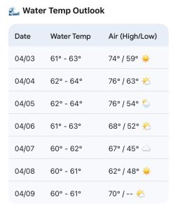
Updated WB water temp forecast. Short arm fullsuits are worth consideration this weekend, but water temps will drop a bit next week.
 Wavewire
 Pics
Pics CAMS
CAMS News
News Contact