
Wrightsville Beach Surf Outlook: April 24–May 1, 2026
Issued 6:30 AM April 24. Note: Forecast based on early Friday morning data. While broad patterns usually hold, forecast shifts occur—verify conditions before heading out.
Fri–Sat: Small S Windswell; Best Loggable Window Early
Sunday: Still Small, Shifty Winds and Rain with Front
Mon–Tue: A Bit More ENE Windswell
Mid-Late Week: Dropping but Low Confidence Forecast
Quality Legend: 🟢 = Fun/Clean; 🟡 = Marginal to Fair at Best; 🔴 = Poor/Blown Out.
Vibe Legend: 🌅=Sunrise; 🪵=Log; 😎=Warm; 📈=Building; 🌬️=Breezy; ⛈️=Rain; 🌤️=Improving; ✨=Clean; 🧘=Small; ❓=Uncertain.
Today through Sunday (4/24–4/26): Small S Windswell; Sunday Front Brings Rain and Shifty Winds
High pressure remains offshore as a cold front gradually approaches. We’re looking at mostly small S windswell through Saturday in the 1–2’ (~knee high) zone, with top spots only doing slightly better on sets. Morning windows will be the cleanest (and offer best tides) before breezy SSW winds add texture each afternoon.
The front crawls through on Sunday, bringing rain and shifty winds. While the first half of the day looks decent wind-wise, conditions will be soggy and marginal. We expect surf to hold in the 1–2’ range, with a slight increase possible late in the day as winds switch N then NE behind the front, but most of the windswell increase now looks like early next week. Note that tides will be low in the mornings through the weekend, which will likely be the time to target.
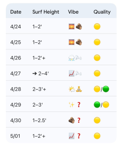
- 4/24 (Friday): 1–2′ (~knee high with only slightly bigger peaks for top spots) in S windswell. High 82°F. Best AM / SSW breezes PM. Quality: 🟡.
- 4/25: 1–2′ (~knee high with only slightly bigger peaks for top spots) in S windswell. High 81°F. Best winds/tides early before breezy SSW winds develop in the afternoon. Quality: 🟡.
- 4/26 (Sunday): 1–2′ (~knee high) surf continues. Low tide longboard waves possible in the morning again but watch for incoming showers. High 74°F. Rain & Shifty Winds. Only slightly strong NE windswell by dark. Quality: 🟡.
Looking Ahead: Building Monday and Quality Midweek
On Monday (4/27), the ENE windswell will be building through the day as low pressure develops offshore. Expect it to start on the smaller side in the morning and ramp up to 2–3′ occ 4′ by the afternoon. It will be breezy with NE winds and a bit cooler (highs near 70).
We see a gradual improvement in quality on Tuesday and Wednesday as the winds gradually diminish. That said, confidence is low on the specifics as the forecast through midweek depends on the evolution of the aforementioned low pressure system offshore. We’ll stick with a ~knee-waist high ENE/E swell forecast through the period but there is some wiggle room for changes either way (up or down). This will likely fade a little through Thursday. Another front late in the week may bring a minor bump in windswell (1–2’+) by Friday, May 1st, with potential for renewed ENE windswell into next weekend but again confidence is low in the details this far out.
- 4/27 (Monday): 1-3’ building to 2–3′ occ 4′ (Knee-Waist with developing Stomach/Chest high peaks) ENE windswell. High 70°F. Building & Breezy NE winds. Quality: 🟡.
- 4/28: 2–3’+ (thigh-stomach high) ENE mix. High 75°F. Winds gradually improving. Quality: 🟡 / 🟢.
- 4/29: 2–3′ (knee-waist high) lingering ENE/E swell but watching offshore low. High 79°F. Potential for cleaner conditions/better winds. Quality: 🟢 / 🟡.
- 4/30: 1–2.5′ smaller knee up to thigh high surf. High 79°F. Quality: 🟡.
- 5/01 (Friday): 1–2′+ potentially for building windswell mix into next weekend. Quality: 🟡.
Final Thoughts
The morning lower tides will likely be the best bet through the weekend, but keep expectations low as there isn’t a lot of swell around. More size is expected early next week. Winds will be a factor Monday but look for that to gradually improve through the middle of the week. The wildcard for next week is low pressure offshore. This has potential to impact the forecast so keep an eye on the buoys and cams.
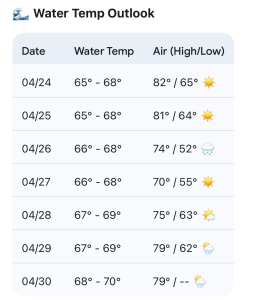
Updated WB water temp forecast. Watch for W winds to bring some upwelling the next couple of mornings. Later next week may be the point where we hit 70 though!
 Wavewire
 Pics
Pics CAMS
CAMS News
News Contact