
Wrightsville Beach Surf Outlook: April 17–April 24, 2026
Issued 6:15 AM April 17. Note: Forecast based on early Friday morning data. While broad patterns usually hold, forecast shifts occur—verify conditions before heading out.
Fri–Sat: Small ESE Swell/S windswell Mix
Sunday: Approaching Front; Slightly More Windswell
Mon–Tue: Slightly Cooler; Small NE windswell/E Swell
Mid-Late Week: Minor Surf but Morning Longboard Windows Likely
Quality Legend: 🟢 = Fun/Clean; 🟡 = Marginal to Fair at Best; 🔴 = Poor/Blown Out.
Vibe Legend: 😎=Warm/Summer-like; 📈=Building; 🌬️=Bumpy/Windy; 🌤️=Cleaning Up; 🧘=Small/Relaxed; 📉=Cooler Temps; 🌅=Sunrise Session; 🪵=Loggable Window.
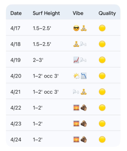
Today through Sunday (4/17–4/19): Small ESE Swell; Watching Sunday Front
Small ESE swell and S windswell mix continues to reach the area this morning as a summer-like, offshore high-pressure weather pattern continues. Look for this to continue to produce mostly knee occ. thigh high (1.5–2.5′) surf today and tomorrow. Overall semi clean to sideshore conditions are expected with SW to SSW breezes (strongest in the afternoon). Winds and conditions on Saturday will best early before an enhanced SSW wind picks up even stronger into the PM hours. Be mindful of the morning high tides the next couple of days.
For Sunday, a cold front will approach the area and eventually push offshore towards the evening. Moderate to strong SW to S winds will trend NW to N late. Expect knee up to waist high (2–3′) mixed windswell and small SE/ESE swell with this, and overall marginal conditions. However, there could be a brief window mid to late afternoon where winds are briefly favorable before N winds blow things out by evening. It is worth keeping an eye on the flags.
4/17 (Friday): 1.5–2.5′ (Knee to Thigh High) ESE swell. High 83°F. SW to SSW winds with occasional sideshore texture especially in the afternoon/evening. Quality: 🟡.
4/18: 1.5–2.5′ (Knee to Thigh High) SE/ESE mix. High 83°F. Light SW winds becoming Stronger SSW winds PM. Best Early But Watch for Morning High Tide. Quality: 🟡.
4/19: 2–3′ (Knee to Waist High) messy S mix but some improvement possible briefly mid to late afternoon as winds shift around front. High 79°F. S/SW winds shifting NW/N late. Quality: 🟡 .
Looking Ahead: Small Windswell and A Little Cooler Early Week; Minor But Morning Longboard Windows Mid-Late Week
High pressure will build in from the Great Lakes region behind the cold front on Monday, before moving over the Mid-Atlantic and Outer Banks coasts just to our north through Tuesday. Look for this pattern to generate mostly small 1–2’ (Shin to Knee High) ENE trending E windswell, with up to thigh/waist high peaks for better spots. High pressure will push just offshore through the middle of next week.
At this point, no significant swell events are forecast, with mostly longboard-type surf anticipated in the shin-knee high (1–2′) zone Wednesday through Friday. Confidence diminishes at these time scales and thus the forecast is subject to change. Winds and conditions are typically best in the mornings with the expected pattern. We will transition to morning low tides as we move through next week, so the early session seems like it will be the best bet (along with having low expectations).
4/20 (Monday): 1–2′ occ. 3ft (Knee high with thigh/waist high peaks better spots) windswell mix. High 69°F. Cooler with N winds, becoming more variable in the afternoons. Quality: 🟡.
4/21: 1–2′ occ. 3ft (Knee high with thigh/waist high peaks for better spots) small E windswell/swell. N to NE breezes trending E/SE later. High 69°F. Quality: 🟡.
4/22 to 4/24: 1–2′ small surf. Highs Mid to Upper 70s. Bigger boards in the mornings (low tides) likely the call before winds get on it. Quality: 🟡.
Final Thoughts
Mornings will be cleaner early in the weekend but watch for high tide. A little more windswell is expected Sunday and it’s not out of the question we will see a very brief window mid to later day when winds are OK. Overall small surf much of next week, but likely some morning bigger board windows mid to late in the week.
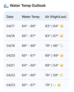
Updated WB water temp forecast. We are well within the short-arm full range now.
 Wavewire
 Pics
Pics CAMS
CAMS News
News Contact