
Wrightsville Beach Surf Discussion: October 31 – November 6, 2025
Issued 8:13 AM EDT, Friday, October 31, 2025. Note: This content will become less and less relevant with time.
- Friday: Overall fun. Likely the best day of the forecast, with fun surf potential.
- Saturday: Easing leftovers with smaller waves and favorable winds.
- Sunday: Marginal surf with developing onshore winds.
- Early Next Week: Small windswell bump but worth watching.
- Mid to Late Next Week: Minimal surf currently expected.
Discussion: The Weekend & Beyond
Today: Halloween Friday Fun
A mix of swells is impacting the area early this Halloween morning. A mid to longer period SE swell (2–3 ft @ 12–15s) from distant Hurricane Melissa is mixing with some lingering local windswell. This, combined with offshore winds (W/NW), is leading to some fun surf potential today.
Expected Size: Mostly inconsistent thigh–waist occasional chest-high sets.
Key Factor: Given the longer period nature of the swell, some spots will pick up more size than others, and it will be finicky based on tides — you may have to do some hunting.
Prime Window: Target the 7:30 AM – 11:30 AM low-tide window for the best conditions. Higher-tide spots will be the call for the afternoon (high tide around 3:30 PM).
Saturday & Sunday: The Fade
With Melissa out of the picture and weak high pressure building over the area through Saturday, expect the trend to be toward smaller surf moving into the weekend.
Saturday (11/1): There will likely be small waves in the knee to thigh high zone for the bigger boards during proper tides. Winds should remain favorable, so it certainly could be worse, but expectations should be on the low side.
Sunday (11/2): Reinforcing high pressure will settle north of the area as a weak low-pressure system or trough tries to develop near the coast. The end result will be a wind shift to the N/NE/E, but not much windswell is expected overall. Surf is expected to be in the knee-high zone and a little bumpy.
Looking Ahead: Next Week’s Limited Potential
Early Week Watch (Nov 3–5):
Models have been wavering for early next week on the potential low-pressure system lifting north of the area. At this point, this pattern only looks to generate a minor amount of windswell in the knee to thigh high zone, with winds shifting between NW/N/NE on Monday and Tuesday before diminishing and further easing surf by Wednesday.
Watch Point: This timeframe is worth keeping an eye on — the models don’t have a great handle on it, so there’s at least a small chance the surf could come in a little bigger than currently forecast.
Later Next Week (Nov 6–7):
At this point, not seeing much surf potential later in the week. High pressure will eventually push offshore, paving the way for a new front, but it doesn’t look like it will generate appreciable windswell.
Bottom Line
While the early week period is worth watching, there isn’t much potential for significant surf next week. Winds will diminish into midweek as high pressure settles, so there could be periods of clean to semi-clean longboard waves during proper tide cycles — but keep expectations low.
Final Notes
Overall Best Forecast Window: Friday looks best, with Saturday in second place during proper tides. Sunday looks pretty marginal. Keep an eye on early next week for a small windswell bump.
Water Temps: This looks like the chilliest Halloween in many years. Water temps are around 64°F and expected to trend slightly lower into the weekend.
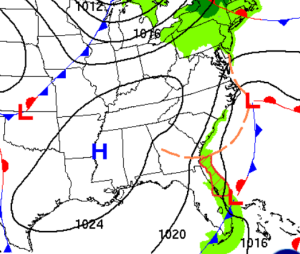
Surface weather map for Monday, showing low pressure near Hatteras with attached fronts extending to the south. This pattern may generate a little windswell for the area but it doesn’t look significant at this point. The early week period is worth watching, however, as models don’t have a great handle on this pattern.
 Wavewire
 Pics
Pics CAMS
CAMS News
News Contact