
Wrightsville Beach New Year’s Surf Outlook: Dec 26 – Jan 2, 2025/26
Issued: 9:30 AM Dec 26
Note: This forecast is based on data from 9:30 AM Friday. While the broad patterns usually hold, the forecast can and does shift especially further out in time. Please verify local conditions before heading out.
By Mark Willis
Outlook Summary
- Today: Bumpy ENE windswell; potentially the most size of the week.
- Weekend: Watching Saturday morning for clean, low tide longboard waves.
- Early Week: Warmer Monday, but minor windswell/swell.
- Closing Out 2025 / New Year: Colder and small scale
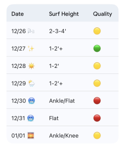
WB Surf Forecast Table: Green = Fair/Good, Yellow = Marginal, Red = Poor/Flat
Today through Sunday (12/26 – 12/28): Easing ENE Windswell into Saturday
A bit of ENE windswell has developed behind a cold front. Buoy 41110 is outperforming the wave model guidance a little, checking in around 5ft @ 6s this morning. This is producing thigh–waist to occasional chest-high surf early today, though it looks to ease through the afternoon.
Winds will begin easing as the surf fades; keep expectations low with the onshore wind today ( Marginal), but it won’t be flat.
Saturday: Early for Clean Longboard Waves
Low pressure diving SE through the Mid-Atlantic moves offshore Saturday. This allows winds to trend offshore tomorrow morning with knee to thigh high leftovers. The offshore window is most reliable from sunrise until around 10:00 AM.
Wind: Light W to NW early, trending NE around 10 kt later.
Tide: Low tide at 6:15 AM (just before sunrise).
Early morning clean 1–2’+ longboard waves are the call ( Fair).
Sunday Transition
High pressure rebuilding from the north brings a brief period of N/NE winds later Saturday into early Sunday. Winds relax later Sunday as the high moves overhead.
End results will be mostly 1–2’+ (knee to thigh high) surf with shifty winds, diminishing into Sunday afternoon. Watch for the midday high tide when those winds lay down ( Marginal).
Looking Ahead: Warm Monday, Colder & Minor to Close Out 2025
A stronger cold front approaches Monday along with breezy, warm SW winds. Minor S windswell will mix with small E swell for mostly knee-to-thigh high surf.
The front moves offshore, bringing an arctic plunge for the last days of 2025. Surf looks knee high or less ( Poor/Flat). New Year’s Day looks minimal, but we’re watching for potential NE/ENE windswell late next week.
 Wavewire
 Pics
Pics CAMS
CAMS News
News Contact