
New weekly feature by expert meteorologist Mark Willis
Wrightsville Beach Surf Outlook: September 26-October 2, 2025
Updated 9:15 PM September 25. Given the rapidly evolving situation in the tropics, the content below has high potential to become outdated quickly as we move into and through the weekend.
-Active tropics with surf likely next week, but details uncertain
-Small, gradually increasing surf through the weekend
-Periods of unsettled weather/rain expected which will impact winds/conditions
-A good time to double check your hurricane kit
Discussion:
Swell from distant, former Tropical Cyclone Gabrielle is all but gone across the area, and smaller surf will be the trend as we head into the weekend. Offshore high pressure will interact with an approaching frontal system from the west to set up mostly minor shin/knee/thigh high surf from the SE through Saturday, with a little more size up to around waist high or so expected Sunday. Pre dawn low tides combined with light winds early will likely lead to the best conditions in the early mornings. Note that the approaching front will lead to periods of unsettled weather this weekend, and winds and conditions will vary around showers/storms. As a result, it is not out of the question to see a window of cleaner surf outside of the morning window this weekend.
Overall Best Weekend Window: Sunday morning. Also, keep an eye on the radar and local winds as conditions may vary some around showers.
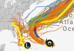
Considerable changes are likely as we move into next week, but the details are highly uncertain. The forecast will be dependent on the evolution of Hurricane Humberto NE of the Leeward Islands and especially the tropical wave moving NW from Hispaniola (“AL94” which may be a tropical depression/storm by the time you read this). The complex interaction between these systems, an upper level trough over the SE US, and surface high pressure well north of the area will undoubtedly lead to a changing forecast in the days to come. One thing, however, seems likely: the chance for much more surf exists next week.
At this point we are expecting (potentially quickly) building surf but with NE/E wind problems on Monday. As the tropical system moving N/NW from the Bahamas nears, there is potential for significant (i.e. chest to head high plus) surf to impact the region through the middle of the week. Winds/conditions will likely be problematic at times, but as the system moves north there could be a window of decent conditions sometime Tuesday or Wednesday (9/30-10/1). As is often the case, there are differences in the major models with this system, with some suggesting the system will stay south of the area leading to continued wind problems. The ultimate fate will have major ramifications on our surf forecast and more importantly, potential hazardous impacts to our area. It is certainly important to monitor official sources for information and update your hurricane kits given the potential for a tropical system to impact the area.
Another thing to be careful with – if Humberto (and/or AL94) end up intensifying as many of the models suggest, we’ll see longer periods mixing in early to mid next week. Wave models and surf forecasts in our area in general tend to over predict things in these regimes. In this case, however, there looks to be no shortage of surf either way for a good chunk of next week.
Next Week Bottom Line/Potential Best Days: Currently looking like Tuesday/Wednesday but monitor wind forecasts closely, seek wind protected spots as needed, and be prepared to wait it out for a window of cleaner surf well down the road after the tropics calm down and high pressure north of the area relaxes. Beware of overdone surf forecasts, monitor hurricanes.gov and weather.gov/ilm for official information related to the tropical threat.
 Wavewire
 Pics
Pics CAMS
CAMS News
News Contact