
Wrightsville Beach Surf Outlook: July 3 – 10, 2026
Issued 6:30 AM July 3. Note: Forecast based on early Friday morning data. While broad patterns usually hold, forecast shifts occur—verify conditions before heading out.
Fourth of July Weekend: Small SE Swell; Best Early
Mon-Wed: A Little More S Windswell Due
Looking Ahead: Small Summertime S Swell
Best Windows of Forecast: Early Fri/Sat Mornings; Midweek Mornings
Legend: 🟢 Clean | 🟡 Semi Clean/Semi Bumpy | 🔴 Choppy | ✨ Clean/Glassy | 🧘 Small/Fun | 🌬️ Breezy | 🌅 Sunrise/AM Window | 📈 Building/Changing | 👀 Keep an Eye On It | ❓ Uncertain
(Note: Split quality colors represent AM / PM sessions)
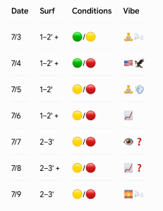
Friday Through Sunday (7/3–7/5): Small SE Swell; Best Winds/Tides Early
ESE swell is down a bit from yesterday but still around 2ft at 8s on buoy 41110 which should translate to knee-thigh high surf. Inconsistent plus sets possible for top spots. Conditions are clean and glassy this morning with light offshore to variable winds. Expect a bit bumpier surf this afternoon as SE to S winds increase to around 8-13mph. The tide was low just before dawn heading to a ~10:10am high tide (following low at 4:15pm), so the early morning window is likely the best combo of winds/tides today. Overall similar surf is expected on the 4th of July, with the best winds/tide early. Note severe parking challenges are likely this weekend.
Wave model guidance shows slightly smaller SE swell for Sunday around knee high, but slightly higher, bumpy peaks possible in the afternoon as S breezes pick up again (5-14 mph, gusts to 21 mph).
- 7/3 (Friday): 1–2′ + (Knee to Thigh High) SE swell — Glassy early with a little more bump in the PM as onshores develop. Inconsistent waist high sets possible top spots. Quality: 🟢 / 🟡.
- 7/4 (Saturday): 1–2′ + (Knee to Thigh High) SE swell — Happy 4th! Clean early with light winds before the afternoon south breeze and heat index in triple digits take over. Quality: 🟢 / 🟡.
- 7/5 (Sunday): 1–2′ (Around Knee High) — Swell drops a bit, but breezy afternoon south winds (gusts to 21 mph) add some choppy, thigh high peaks late. Quality: 🟡 / 🔴.
Looking Ahead: Occasional Enhancements in S Windswell
Offshore high pressure will gradually interact with a weak front approaching over early to mid next week. This combined with typical afternoon sea breeze will lead to occasional enhancements in S windswell. Look for 1-2’ surf Monday morning with plus peaks over the afternoon/evening. Slightly stronger surf through the middle of the week especially in the late afternoon and early evenings (Knee-thigh-waist, occ. slightly higher peaks late day). Conditions will likely be best in the mornings before SSW winds blow things out in the afternoon/early evenings. Watch for increasing storm chances (30% to 50%) starting Monday evening through mid-week.
Overall similar 1-2-3’ S windswell is expected for the second half of next week, again with the best winds in the mornings before SSW winds get to it each afternoon.
- 7/6 (Monday): 1–2′ + (Knee-Thigh) — Best early before SSW winds get on it. Slightly bigger peaks late in the day. Quality: 🟢 / 🟡.
- 7/7 (Tuesday): 2–3′ (Knee-Waist) — S windswell peaks. Best shape early; strongest in the afternoon/early evening but bumpier then. Quality: 🟢 / 🟡.
- 7/8 (Wednesday): 2–3′ (Knee-Waist) S windswell — Maybe slightly higher than waist high peaks late day but choppier then. Best winds/conditions early (could be “green” but being conservative this far out). Quality: 🟢 / 🟡.
- 7/9-10 (Thursday and Friday): 1-2–3′ (Knee-Thigh Occ. Waist) — Lingering south windswell. Cleanest early before SSW winds increase. Quality: 🟢 / 🟡.
Tropical Update
The tropics are quiet at this time.
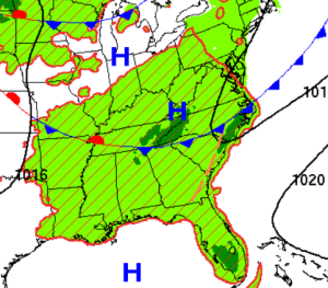
This chart is for Wednesday morning (July 8). A weak front approaches allowing S windswell to pick up slightly. Keep an eye on this front as it may lead to a period of better morning winds around midweek with small S windswell in the water.
 Wavewire
 Pics
Pics CAMS
CAMS News
News Contact