
Wrightsville Beach Surf Outlook: March 6–13, 2026
Issued 6:45 AM March 6. Note: Forecast based on early Friday morning data. While broad patterns usually hold, forecast shifts occur—verify conditions before heading out. By Mark Willis
- Today/Friday: Small to Fun-Sized SE Swell; Dense Morning Fog
- Weekend: Clean Morning Windows; Summerlike Pattern; Lingering Fog
- Early Next Week: Slowly Fading SE Swell
- Late Next Week: Fading Mid-week; Possible Friday Pulse 📈
Vibe Legend: 🪵=Loggable; ✨=Clean Faces; 📈=Building; 📉=Fading; 🌬️=Bumpy/Windy; 🌫️=Fog Potential; 🧘=Small/Relaxed; ☕=Chill Morning; ❓=Uncertainty.
Quality Legend: 🟢 = Fun/Clean/Fair; 🟡 = Marginal to Fair at Best; 🔴 = Poor; ❓ = High Uncertainty.
Today through Sunday (3/6–3/8): Lingering Small SE Swell
A summerlike weather pattern persists with offshore high pressure pumping in warm air and small SE swell. Buoy 41110 is currently holding just under 3ft at 10s, delivering surf in the 2–3′ (knee-waist high) zone.
The Bottom Line: The surf will be better super early in the morning due to the favorable winds and tides. Dense fog is currently a major factor with visibility under a mile; this will be a theme over the next couple of days especially in the mornings. Conditions will trend from clean to textured/bumpy each afternoon as SSW/S winds increase.
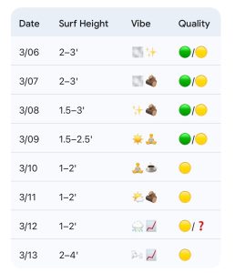
- 3/06 (Friday): 2–3′ (Knee to Waist High) SE swell. High 72°F. Dense morning fog. Quality: 🟢 AM / 🟡 PM.
- 3/07: 2–3′ (Knee to Waist High) small SE energy. High 71°F. Patchy morning fog. Quality: 🟢 AM / 🟡 PM.
- 3/08: 1.5–3′ (Knee to Thigh Occ. Waist High) small leftovers. High 72°F. Light offshore morning winds. Quality: 🟢 AM / 🟡 PM.
Looking Ahead: Lingering Monday Swell; Fading Midweek; Friday Pulse?
The warm pattern remains entrenched through early next week. Monday (3/9) offers slowly fading SE swell with 1.5–2.5’+ surf. Highs will stay in the mid-70s. Most major models suggest potential for building windswell around the next cold front later next week. If the front clears as expected, we could see a pulse of 2–4′ ENE to E windswell by Friday (3/13).
- 3/09 (Monday): 1.5–2.5′ (Knee to Thigh High) lingering SE swell. High 72°F. Quality: 🟢 AM / 🟡 PM.
- 3/10–3/11: 1–2‘ (Ankle to Knee High) leftovers. Highs near 75°F. Quality: 🟡.
- 3/12: 1–2′ 📈 Building windswell potential late. High 72°F. Quality: 🟡 / ❓.
- 3/13: 2–4′ potential ENE windswell. Bumpy but building. Quality: 🟡.
Final Thoughts
Small but rideable SE swell for the next few days. Conditions will be best early, but fog will be problematic at times. Watching for another potential windswell later next week.
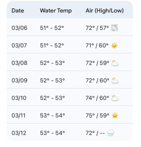
Updated WB water temp forecast: We should see continued gradual warming.
 Wavewire
 Pics
Pics CAMS
CAMS News
News Contact