
Wrightsville Beach Surf Outlook: October 24–October 30, 2025
Issued 6:30 AM October 24. Note: This content will become less and less relevant with time.
-
- Small scale surf on Friday but with favorable winds
- Minor surf continues into the weekend with bumpier conditions
- Building ENE windswell early week; watching for a ~midweek cleanup
- Potential for SE swell from Melissa later next week
Discussion:
Rather unfavorable surf conditions are impacting the area in the pre-dawn hours on Friday, and this looks to be the trend in the near term. Buoy 41110 is checking in around 2ft at 9s from the SE, and I suspect this will lead to mostly knee high or so surf today, and mostly longboardable on proper tides. The good news for today (Friday 10/24) is that winds will be at least somewhat favorable most of the day today, with semi clean to clean conditions overall.
An area of high pressure over the Ohio River Valley will strengthen as it moves N/NE over eastern Canada through the end of the weekend. This sets up gradually increasing NE winds through Sunday along with a touch more windswell by late in the weekend. Overall though, it is not looking like a great weekend of surf. I’d expect mostly poor ankle–knee high surf Saturday with slightly bigger peaks but bumpy on Sunday. Water temps are around 68°F right now at JMPN7, and look for that to potentially drop slightly with fall-like weather this weekend.
Overall Best Weekend Window: The options are limited. Low tide longboard waves are likely the only call, and even that may be a stretch with increasingly bumpy conditions. Sunday overall will see slightly more size but also a bit choppier. Meanwhile Friday (today) will have the best winds/conditions.
There is potential for a bit more surf heading into next week, but the details are about as clear as mud at this point. Strong high pressure will continue north of the area through early week. Meanwhile, an upper level disturbance will move east through the Southeast U.S. states that ultimately will likely induce an area of low pressure to develop just offshore. This pattern will likely lead to an increase in NE to E windswell with surf generally in the thigh–waist–chest high zone on Monday and Tuesday but bumpy, along with periods of unsettled/rainy weather.
As low pressure lifts north, there is potential for winds and conditions to improve as we move through the middle of the week. As a result, sometime later Tuesday, Wednesday, and/or Thursday seems to be the call for next week.
Another wildcard next week is Tropical Storm Melissa. Melissa is likely to strengthen (and potentially significantly) while moving slowly in the Caribbean over the next few days as it unfortunately produces detrimental impacts for Jamaica, Hispaniola, and parts of Cuba. It is eventually expected to emerge into the SW North Atlantic around mid or late next week. Depending on its exact track and intensity, it could lead to another pulse of swell around the second half of next week. Predictability of this is limited this far out, but there is certainly potential for a little trick or treat swell for the area. The challenge right now is models are not in great agreement on when the storm will emerge into the SW North Atlantic after impacting portions of the Caribbean.
Next Week Bottom Line/Potential Best Days: The midweek timeframe (late Tue through Thu) is what we are eyeing right now. Plenty of surf potential with a potential coastal low and Tropical Cyclone Melissa lifting N/NE out of the Caribbean. Melissa swell could be delayed pending on when it emerges into the Atlantic. Its track/intensity after impacting the Caribbean will also determine how significant the swell is, so stay tuned.
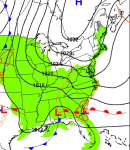
Surface weather map for Monday, October 27, showing strong, fall-like high pressure north of the area with developing low pressure near the SE US coast. This will produce building windswell for the area into early next week, with potential for improving conditions as we move into and through the middle part of the week.
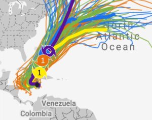
Various computer model simulations for Tropical Cyclone Melissa as seen by Google’s Weather Lab. Melissa is expected to strengthen into a hurricane the next couple of days and potentially produce devastating impacts for parts of the Caribbean. Mid to longer period SE swell is possible for WB around the back half of next week. There are differences in the models on when this storm will emerge into the SW North Atlantic, however, which will impact the swell/surf forecast.
 Wavewire
 Pics
Pics CAMS
CAMS News
News Contact