
|
BEST SHAPE
Fri/Sat/Sun
|
BIGGEST SURF
Wednesday into Thursday
|
TIMES TO WATCH
Late Next Week/Next Weekend
|
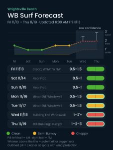
Conditions Clean · Semi Bumpy · Choppy
Each day’s pill is split — left half is the morning session, right half is the afternoon.
Issued 6:00 AM November 13. Note: Forecast based on early Friday morning (11/13) data. While broad patterns usually hold, forecast shifts occur—verify conditions before heading out.
Friday–Sunday 11/13–11/15 — Small S Swell Friday; Minor This Weekend
Buoy 41110 has dropped overnight and is showing a small S swell in the 7-8 second period band this morning. Look for this to produce mostly shin high surf with occasional knee high sets at top spots. Winds are WNW this morning and trend more NW later as a front moves through, so conditions should be clean — sunny with a high near 63 and winds 8 to 11 mph gusting to 17. We’ve got a high tide at 9:30 AM and a low tide around 4 PM, so look for a few longboard waves early on the incoming tide at better spots that can handle a little water, and again as the tide drops later this afternoon.
Unfortunately, the surf looks pretty minimal this weekend as high pressure builds over the area from the Midwest and produces NNW to NW winds and surf mostly around ankle to shin high. Cool weather is expected with this pattern with highs in the upper 50s under abundant sunshine — near 58 Saturday with NW winds 9 to 11 mph gusting to 18, and near 57 Sunday. Nights turn cold, down around 37 Saturday night.
Monday–Thursday 11/16–11/19 — Minor Mon/Tue; Building ENE Windswell Later Week
High pressure will build over the Ohio River Valley early next week allowing local winds to trend more NNE. Unfortunately this doesn’t look to produce much — shin to knee high surf at best, along with a bit of sideshore texture.
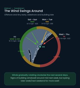
There is a little more potential for some surf mid to late next week. Most models suggest high pressure will slowly migrate east to our north through midweek. This should gradually allow for winds to trend more NE to ENE in the 12-16 mph range, setting up bumpy 1-2’+ peaks with up to thigh-waist high sets for top spots by Thursday. In addition, there is also some indication that low pressure will develop E/NE of the Bahamas later next week while interacting with the aforementioned high pressure to our north. This could allow for a little more ENE trending ESE swell as we move through late week and next weekend. At this point, though, the main swell from this pattern looks to arrive beyond this forecast window — into next weekend — so we’ve capped Thursday at 1-2′ with occasional 3′ sets, with winds likely moderate NE to ENE. Confidence is low in specifics at this time.
Sunny and gradually milder through the stretch, with highs near 58 Monday, 60 Tuesday, 65 Wednesday and 69 Thursday, and overnight lows in the low to mid 40s.
Tropical Update
The tropics are quiet as we near the end of the 2026 hurricane season.
 Wavewire
 Pics
 CAMS
 News
 Contact