
|
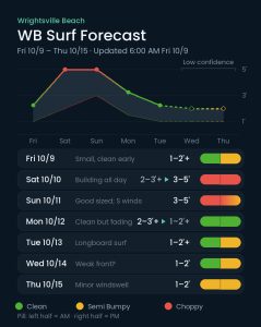
BEST SHAPE
Monday morning
|
BIGGEST SURF
Sat evening into Sunday
|
TIMES TO WATCH
Late Sunday for a partial cleanup; Monday as the swell fades
|
Conditions Clean · Semi Bumpy · Choppy
Each day’s pill is split — left half is the morning session, right half is the afternoon.
Issued 6:00 AM October 9. Note: Forecast based on early Friday morning (10/9) data. While broad patterns usually hold, forecast shifts occur—verify conditions before heading out.
Friday–Sunday 10/9–10/11 — Building ESE Trending SSE Swell This Weekend
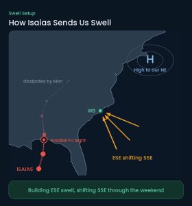
Hurricane Isaias will make landfall along the northern Gulf Coast late Friday into early Saturday. The storm will then weaken quickly as it moves north then northeast towards and through the Tennessee River Valley. As the system interacts with strong high pressure moving over and then offshore of New England, expect rising ESE shifting SE/SSE windswell for the weekend.
Friday will stay relatively small with mostly knee, occasionally thigh high surf. Conditions are cleanest early with light offshore NW winds, which trend N/NE and then E at 6 to 11 mph through the day, adding chop as it goes. Mostly cloudy with a high near 78.
Expect steadily building surf during Saturday, with 2–3’+ surf building to 3–5′ (waist to head high) by evening. However, strong onshore E winds of 18 to 23 mph, gusting past 30, will produce mostly blown out, poor conditions. Showers and thunderstorms are likely through the day, with another 1 to 2 inches of rain possible Saturday night.
Lingering 3–5′ surf Sunday will continue to have problematic winds, but this time from the S shifting SSW at 14 to 18 mph. Some slight improvement is possible late, but it doesn’t look like we’ll fully realize a cleanup until Monday. That said, with all of the rain moving through, it will be worth monitoring for a potential partial or temporary clean up, especially later Sunday afternoon.
Monday–Thursday 10/12–10/15 — Fading but Fun Monday; Smaller Through Midweek
Monday is a day to watch as lingering SSE/SE swell from the weekend fades but meets favorable offshore W to WNW winds. Expect 2–3’+ early, but this one will be fading through the day — by late afternoon look for waist high sets few and far between. Watch the morning high tide as well. The lunchtime tide drop is probably worth a check for a few waist plus peaks, but expect it to be dropping. Columbus Day otherwise looks sunny with a high near 81.
Expect the surf to drop to knee to thigh high or so on Tuesday, but there should still be enough for the longboards. Clean to semi clean conditions from light N/NE winds, with a possible PM sea breeze. Plenty of sunshine with highs around 80 through midweek.
No significant swell events are expected Wednesday or Thursday, with mostly knee up to thigh high surf. There are some differences in the models with respect to a weak front around this time, but regardless, only minor windswell is expected from this along with small underlying ESE swell.
Tropical Update
Isaias is forecast to peak near 120 mph Friday afternoon before coming ashore on the northern Gulf Coast late Friday night. It then weakens fast inland — down near 40 mph by Saturday afternoon and dissipating by Monday morning. It will indirectly send swell our way this weekend before fading and improving early next week. Isaias is also the Atlantic’s first hurricane of 2026, capping what had been a record-slow season. Elsewhere, the tropics are quiet.
 Wavewire
 Pics
 CAMS
 News
 Contact