
Wrightsville Beach Surf Outlook: August 7 – August 13, 2026
Issued 6:30 AM August 7. Note: Forecast based on early Friday morning (8/7) data. While broad patterns usually hold, forecast shifts occur—verify conditions before heading out.
Weekend: Modest SE Swell Increase Sat; Best in AM
Mon–Wed: Small, Typical S/SE Swell
Later Week: Mostly Persistent Small Summer Surf
Best Windows of Forecast: Sat AM looks best, then Sun AM
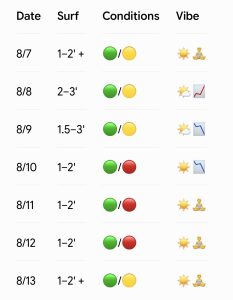
Legend: 🟢 Clean | 🟡 Fair/Semi Bumpy | 🔴 Poor/Choppy
Vibe Key: ☀️ Summer Sun | 🧘 Relaxed / Longboard Session | 🌤️ Partial Sun | 📈 Building Swell Pulse | 📉 Fading Swell
(Note: Split quality colors represent AM / PM sessions)
Friday Through Sunday (8/7–8/9): Modest Increase in SE Swell for Saturday
High pressure over the Atlantic waters just west of Bermuda will interact with a weak trough of low pressure just off the Florida/Southeast Coast as we move into the weekend. While Friday will continue to see surf mostly around 1–2 ft+ (knee up to thigh high), expect this pattern to lead to a slight increase in SE swell for Saturday (2–3 ft, with more consistent thigh-to-waist high sets). This slowly eases through Sunday back down to 1.5–3 ft (knee to waist high).
Winds will be light SW to variable in the early mornings Friday and Saturday before picking up out of the SSW to S (5–11 kt) for the afternoons. Note that most models suggest there is potential for the winds to be a little more offshore Sunday morning before again trending SSW/S around 8–12 kt for the afternoon. As a result, expect the cleanest conditions in the morning hours.
Tide Timing: Tides will generally be favorable in the mornings when the best winds are, featuring an ~8:30 AM low on Friday, an ~9:45 AM low on Saturday, and an ~10:45 AM low on Sunday. Many spots will offer the best shape within a couple of hours on either side of these low tides.
Looking Ahead: Overall Typical Summertime Surf
Overall, a typical small, summertime S/SE swell mix is expected early to mid next week as offshore high pressure interacts with standard inland troughing. This sets up mostly 1–2 ft (knee to occasionally thigh high) surf for Monday through Wednesday, with a smidge more S windswell potential by Thursday..
Winds and surface conditions will be best in the morning hours before SSW/S winds ramp up each afternoon. There are some indications that winds will stay more offshore (WSW) for longer in the day by the middle of the week, so keep an eye on that. However it is really hard for it not to go SSW at some point in the afternoon this time of year, so be suspicious of models/forecasts that suggest all day offshore flow. Note that we will trend towards early morning high tides over early to mid next week, so you’ll need to choose your morning spots wisely when the winds are most favorable.
🌀 Tropical Update
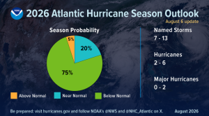
No tropical development is expected over the next 7 days. NOAA’s August hurricane season update came out yesterday, maintaining expectations for a below-normal season. As a reminder, this does not necessarily mean we’ll see a below-average surf season—there is plenty of time left in the 2026 Atlantic hurricane season!

 Wavewire
 Pics
Pics CAMS
CAMS News
News Contact