
Wrightsville Beach Surf Outlook: June 5–June 12, 2026
Issued 6:30 AM June 5. Note: Forecast based on early Friday morning data. While broad patterns usually hold, forecast shifts occur—verify conditions before heading out.
Fri-Sun: Small to Fun E Swell Today; Transitioning to Small Summer-Like Weekend
Mon-Tue: Clean & Small Mon, Slight Bump Up Tue w/ Front
Mid/Late Week: Gradual Return to Summer Pattern; Watch Changing Morning Tide Cycles
Best Day of Forecast: Likely Today
Legend: 🟢 Fun/Clean | 🟡 Marginal/Fair | ✨ Clean/Glassy | 🧘 Small/Fun | 🌬️ Breezy | 🌅 Sunrise/AM Window | 📈 Building/Changing | ❓ Uncertain
Weekend (6/5–6/7): Small to Fun E Swell Today; Summer-Like Weekend Conditions
We still have some small E swell (Buoy 41110 hovering around 2-3 ft @ 9s) impacting the greater Cape Fear beaches this morning as a result of a Gale Force low pressure system that developed offshore in the SW North Atlantic. This size swell will produce around knee-to-waist high surf today, although stomach-high sets are not out of the question for standout spots. Winds are light offshore this morning and the tide is low (moving to an ~11:30 AM high tide), so it’s well worth a check around the area. SSW winds will impact conditions this afternoon/evening.
The aforementioned low pressure system, now roughly 500-700 miles E/ENE of Wrightsville Beach, will weaken as it lifts out to sea this weekend. Meanwhile, high pressure will gradually move off the Southeast US Coast. This will set up a summer-like weather pattern for the area, along with a bit smaller SE swell and local S windswell mix. Overall look for 1.5-2.5’ surf (knee-to-thigh high) this weekend, with the best combination of winds and tides in the mornings. Breezy SSW winds will become problematic in the afternoons.
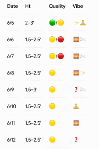
- 6/5 (Friday): 2–3′ (Knee-to-waist high, occ. stomach-high sets early). High 89°F. Best winds and tides in the morning. SSW winds 10-15 mph add texture by afternoon. High 86°F. Quality: 🟢 / 🟡.
- 6/6 and 6/7 (Saturday and Sunday): 1.5–2.5′ (Knee-to-thigh high). Summer-like mix. Best early with light SW winds and a lower tide, turning bumpy as SSW winds build to 13-18 mph in the PM. High 88-90°F. Quality: 🟡.
Looking Ahead: Watching Early Week Front; Otherwise Small Summer Time Surf
Summer-like, small SE swell continues into next week, with mostly knee, occasional thigh-high surf into Monday. A cold front is expected to approach the area on Monday so winds should be favorable, especially in the morning/early afternoon.
Beyond that, there are some discrepancies in the models with how far south the cold front will make it, and how strong the post-frontal high pressure will be—not uncommon for this time of the year. Overall, we are expecting mostly 1-3′ (knee-to-thigh, occ. waist-high) mix of SE swell and new, local ENE windswell on Tuesday, noting there is some uncertainty in the forecast.
It looks like we will gradually return to a more summer-like weather pattern later next week as high pressure moves offshore. This often spells knee up to thigh-high SE swell with the best winds in the mornings before SSW breezes kick in for the afternoon/evenings. Note we’ll have morning low tides through early week but will gradually shift to a morning higher tide by the end of next week.
- 6/8 (Monday): 1.5–2.5′ (Knee-to-thigh high). Favorable morning/early afternoon wind window ahead of the approaching cold front, though surf remains on the smaller side. High upper 80s. Quality: 🟢.
- 6/9 (Tuesday): 1.5–3′ (Knee-to-thigh, occ. waist-high sets). Surf bumps up slightly from a new ENE windswell mix. Forecast uncertainty remains depending on front/high pressure strength. High around 80. Quality: 🟡.
- 6/10 (Wednesday): 1.5–2.5′ (Knee-to-thigh high) mix. Likely best early. High low 80s. Quality: 🟡.
- 6/11-12 (Thursday and Friday): 1.5–2.5′ (Knee-high SE swell). Returning to a standard summer pattern. Best early before afternoon SSW sea breezes build. Morning tide shifting to high. Quality: 🟡.
Tropical Update
The Atlantic Hurricane Season is now underway, but there is no tropical activity expected across the basin for the next 7 days.
For the broader context on how the year might unfold, NOAA recently released its official 2026 Atlantic Hurricane Season Outlook. For the first time in over a decade, forecasters are predicting a below-normal season (55% probability), calling for 8 to 14 named storms, 3 to 6 hurricanes, and 1 to 3 major hurricanes. The primary climate driver behind this quieter outlook is the anticipated development of a strong El Niño event, which typically fosters high vertical wind shear across the tropical Atlantic to suppress major storm organization.
The Surf Perspective: It is worth noting that a below-normal hurricane season does not automatically translate to a below-normal surf season. In fact, sheared, weaker tropical systems often generate fun swell events for our coastline vs. long, walled out closeouts most of our beaches often can’t handle. This will certainly be worth watching during the developing El Nino.
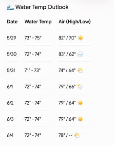
Updated WB water temp forecast.
 Wavewire
 Pics
Pics CAMS
CAMS News
News Contact